|
| ||||||||||||||||||||
Please note that JDLand is no longer being updated.
peek >>
Near Southeast DC Past News Items
- Full Neighborhood Development MapThere's a lot more than just the projects listed here. See the complete map of completed, underway, and proposed projects all across the neighborhood.
- What's New This YearA quick look at what's arrived or been announced since the end of the 2018 baseball season.
- Food Options, Now and Coming SoonThere's now plenty of food options in the neighborhood. Click to see what's here, and what's coming.
- Anacostia RiverwalkA bridge between Teague and Yards Parks is part of the planned 20-mile Anacostia Riverwalk multi-use trail along the east and west banks of the Anacostia River.
- Virginia Ave. Tunnel ExpansionConstruction underway in 2015 to expand the 106-year-old tunnel to allow for a second track and double-height cars. Expected completion 2018.
- Rail and Bus Times
Get real time data for the Navy Yard subway, Circulator, Bikeshare, and bus lines, plus additional transit information. - Rail and Bus Times
Get real time data for the Navy Yard subway, Circulator, Bikeshare, and bus lines, plus additional transit information. - Canal ParkThree-block park on the site of the old Washington Canal. Construction begun in spring 2011, opened Nov. 16, 2012.
- Nationals Park21-acre site, 41,000-seat ballpark, construction begun May 2006, Opening Day March 30, 2008.
- Washington Navy YardHeadquarters of the Naval District Washington, established in 1799.
- Yards Park5.5-acre park on the banks of the Anacostia. First phase completed September 2010.
- Van Ness Elementary SchoolDC Public School, closed in 2006, but reopening in stages beginning in 2015.
- Agora/Whole Foods336-unit apartment building at 800 New Jersey Ave., SE. Construction begun June 2014, move-ins underway early 2018. Whole Foods expected to open in late 2018.
- New Douglass BridgeConstruction underway in early 2018 on the replacement for the current South Capitol Street Bridge. Completion expected in 2021.
- 1221 Van290-unit residential building with 26,000 sf retail. Underway late 2015, completed early 2018.

- NAB HQ/AvidianNew headquarters for National Association of Broadcasters, along with a 163-unit condo building. Construction underway early 2017.

- Yards/Parcel O Residential ProjectsThe Bower, a 138-unit condo building by PN Hoffman, and The Guild, a 190-unit rental building by Forest City on the southeast corner of 4th and Tingey. Underway fall 2016, delivery 2018.

- New DC Water HQA wrap-around six-story addition to the existing O Street Pumping Station. Construction underway in 2016, with completion in 2018.

- The Harlow/Square 769N AptsMixed-income rental building with 176 units, including 36 public housing units. Underway early 2017, delivery 2019.

- West Half Residential420-unit project with 65,000 sf retail. Construction underway spring 2017.
- Novel South Capitol/2 I St.530ish-unit apartment building in two phases, on old McDonald's site. Construction underway early 2017, completed summer 2019.
- 1250 Half/Envy310 rental units at 1250, 123 condos at Envy, 60,000 square feet of retail. Underway spring 2017.
- Parc Riverside Phase II314ish-unit residential building at 1010 Half St., SE, by Toll Bros. Construction underway summer 2017.
- 99 M StreetA 224,000-square-foot office building by Skanska for the corner of 1st and M. Underway fall 2015, substantially complete summer 2018. Circa and an unnamed sibling restaurant announced tenants.
- The Garrett375-unit rental building at 2nd and I with 13,000 sq ft retail. Construction underway late fall 2017.
- Yards/The Estate Apts. and Thompson Hotel270-unit rental building and 227-room Thompson Hotel, with 20,000 sq ft retail total. Construction underway fall 2017.
- Meridian on First275-unit residential building, by Paradigm. Construction underway early 2018.
- The Maren/71 Potomac264-unit residential building with 12,500 sq ft retail, underway spring 2018. Phase 2 of RiverFront on the Anacostia development.
- DC Crossing/Square 696Block bought in 2016 by Tishman Speyer, with plans for 800 apartment units and 44,000 square feet of retail in two phases. Digging underway April 2018.
- One Hill South Phase 2300ish-unit unnamed sibling building at South Capitol and I. Work underway summer 2018.
- New DDOT HQ/250 MNew headquarters for the District Department of Transportation. Underway early 2019.
- 37 L Street Condos11-story, 74-unit condo building west of Half St. Underway early 2019.
- CSX East Residential/Hotel225ish-unit AC Marriott and two residential buildings planned. Digging underway late summer 2019.
- 1000 South Capitol Residential224-unit apartment building by Lerner. Underway fall 2019.
- Capper Seniors 2.0Reconstruction of the 160-unit building for low-income seniors that was destroyed by fire in 2018.
- Chemonics HQNew 285,000-sq-ft office building with 14,000 sq ft of retail. Expected delivery 2021.
2006 Blog Posts Since 2003
Go to Page: 1 | 2 | 3 | 4 | 5 | 6 | 7 | 8 | 9 | 10 ... 201
Search JDLand Blog Posts by Date or Category
Go to Page: 1 | 2 | 3 | 4 | 5 | 6 | 7 | 8 | 9 | 10 ... 201
Search JDLand Blog Posts by Date or Category
A couple small things from the past few days:
* For the second time in eight years, Capitol Quarter's EYA has been named America's Best Builder by Builder Magazine, which cited "its commitment to high-quality design, building in areas featuring life within walking distance, and industry leading results on homebuyer satisfaction and referral sales."
* From WTOP, news that the current occupants of the encampment at First and M are seeing the tab for their move escalate a touch: "The estimated cost of building a sprawling new complex at Fort Belvoir to house [the National Geospatial-Intelligence Agency] and its 8,500-strong work force will be $350 million more than prior estimates, according to a report from government auditors." It's mandated that they have to be moved into their new digs by September 2011, but the GAO report "warned that the agency's small window for delays means that 'any unmitigated disruptions can jeopardize' meeting the 2011 deadline." The price tag is now $2.44 billion.
* Today's Examiner has another installment of their Three-Minute Interview series, this time with, um, me. (Nationals historians might enjoy knowing that the accompanying photo [better non-cropped version here] was taken the night the team came home from spring training to see their completed ballpark for the first time.)
|
Comments (0)
|
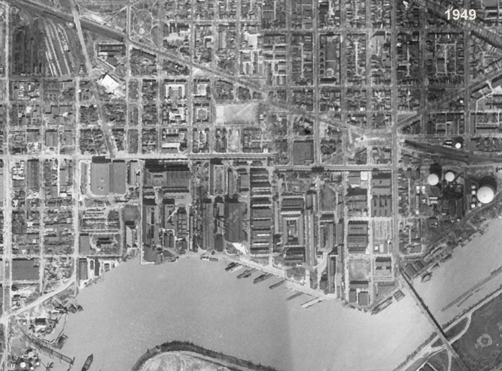 With great thanks to reader G. for passing this along, I can report that the newly released Google Earth 5.0 (beta, of course) now includes an option to page back through older satellite photos. As you might imagine, I raced to see what they had for Near Southeast, and found a not-razor-sharp 1949 image, which you can see on my Near Southeast Satellite Photos page if you don't have Google Earth.
You might enjoy the "Where's Waldo?" test of looking for buildings you recognize, such as the Southeastern Bus Garage, the WASA buildings, and even that big brick warehouse at South Capitol and O that was demolished to make way for the ballpark. Things that *aren't* there: the Southeast Freeway (built in the 1960s), the second span of the 11th Street Bridges, a completed Douglass Bridge, and many of the Capper buildings that came in the 1950s. You'll also see how packed with buildings the Navy Yard was, especially since this was still during the time that its boundaries stretched all the way to First Street (across what is now The Yards). And look at how, north of Virginia Avenue, Garfield Park was bisected by Second Street.
The other image offerings from Near Southeast are mostly variants on the ones I already have on my satellite photos page that came from non-Google sources over the years (1988, 2002, 2004, 2006, 2007), though there are a few extras from the later years where the quality of the image isn't all that good.
If this is whetting your appetite, I also have a batch of non-satellite historic photos of the neighborhood you can wander through, along with detailed street maps from 1903 through 1921.
UPDATE: Commenter MJM rightly reminds me of a fact that an American History major such as myself should have remembered: Sputnik was the first *satellite*, launched in 1957. So these overhead images from 1949 are not satellite images, but were taken from planes. Or they attached a camera to Superman and had him fly around the globe a few times.
|
Comments (0)
|
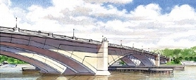
ANC 6D heard a presentation on Monday night from the team working on the South Capitol Street Environmental Impact Statement, which is now in its "final preferred alternative" stage. Their PowerPoint presentation was pretty close to the one I posted last month, and one of the consultants did tweak me a bit about how I "spoiled the surprise" on the choice of the arched bascule design for the new Douglass Bridge.
Here again are the (long!) bullet points about what the preferred alternative designs are for the portion of South Capitol west of the Anacostia (see the presentation if you're interested in the preferred alternatives chosen for east of the river), along with some issues raised by the ANC:
* It was emphasized that these new designs will not be adding any capacity, but that the main goal is to bring back the "boulevard" feeling of the corridor.
* The new bridge will have 20-foot-wide sidewalks on each side, and only two piers will need to be built in the river, compared to 3-5 piers that would have been needed with the other designs. (The cable stayed swing bridge would have had just one pedestrian/bike path, 16 feet wide, in the middle of the bridge, surrounded by six lanes of traffic.)
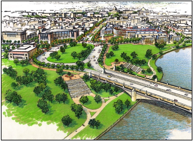 * There will be a seven-acre traffic oval at the foot of the new bridge (which will be located to the south of the current bridge), reshaping the intersection of South Capitol Street and Potomac Avenue. (The ballpark's Home Plate Gate and entrance promenade will be the northeast edge of the oval.) The city is already in the process of acquiring seven properties or portions of properties that will be needed for the oval and bridge footprint, including the red brick warehouse on the northwest corner of South Capitol and Potomac. This oval is on the NCPC list of locations for future memorials and museums.
* The intersection of South Capitol Street and M Street will become an at-grade intersection (no more underpass for through traffic). ANC chair Andy Litsky expressed great concern about how this could make the intersection even more dangerous than it already is, to which the DDOT team replied that the reconfiguration should make it safer. (Certainly it would seem that having a "normal" intersection with two left-turn lanes in most directions would be an improvement safety-wise over the existing mish-mash of lights and poorly striped turn-lanes, but then there will also be a lot more cars cycling through once the tunnel lanes are gone.)
* There will be modifications to South Capitol's interchange with the SE/SW Freeway, with the replacement of the ramp that begins at I Street with an at-grade intersection underneath the freeway that would have two left-turn lanes to a new ramp. With the existing ramp removed, the intersection at South Capitol and I would also be reconfigured.
* The northern section of South Capitol Street will match the reconfigured portion between N Street and Potomac Avenue, as a six-lane boulevard with a median and wide sidewalks.
Commissioners McBee and Moffatt asked as they have in the past about whether the existing bridge could be kept as a pedestrian/bike-only bridge, but DDOT explained that since the swing span would continue to need to be opened for river traffic, the cost of maintaining the old bridge just isn't feasible. (The RiverFront folks might also be a teensy bit upset that their land that's beneath the current bridge wouldn't be coming back to them.) And the team also indicated that this new bridge does not preclude the construction (Some Day, Perhaps, in Some Far Off Time) of a tunnel to move non-local traffic from Anacostia to I-395.
They expect the final Record of Decision from the feds this fall; however, when pressed for a start date, they said 2011 would be the absolute earliest for the start of construction (with completion possibly in 2015), but that as of now there's no funding for the $700 million project. It's also possible that portions of the designs could be undetaken if partial funding is received.
|
Comments (0)
|
Tonight ANC 6D had a special "presentation" meeting, to lighten the load of next Monday's business meeting so that everyone could go home before 2 am. On the agenda were three items, all of which are JDLand perennials. I'll post on Tuesday about the Capper zoning stuff and the South Capitol Street EIS, which didn't really contain much that I haven't previously covered; the third item was the designs for the second phase of the waterfront park at the Yards.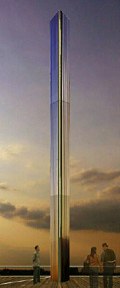 The first phase, which is expected to begin construction in the next three months and be completed by mid-2010, is the basic layout of the park and the boardwalks. The second phase comprises 55,000 square feet of retail in the to-be-rehabbed Lumber Storage Shed and two new buildings, as well as a 60-foot-tall "visual marker" (seen at left) just to the southwest of the shed. (The third phase will be the piers and marina.) I was dreading coming home to describe these latest plans with no renderings to accompany my ramblings, but then I found the National Capital Planning Commission has done all my work for me, thanks to these phase 2 designs being in front of the commission at their meeting this Thursday (and for which the NCPC staff has recommended approval). You can see all of the drawings presented to the ANC in this NCPC document, along with a lot of description of the designs, but I'll hit some highlights.
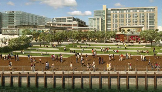 The storage shed, as I've mentioned in the past, will lose its faaaahbulous salmon-colored corregated skin and will be enclosed with non-reflective glass. The other two buildings (currently given the wonderfully descriptive monikers of P2A and P2B) will also be mainly glass structures. There will be a restaurant court in front of the center building, overlooking the area of the park that steps down toward the waterfront. (A drawing of the three buildings' southern facades is here; a larger version of the rendering at right showing how the buildings are not at all dominant when viewed from the waterfront is here. See the NCPC document for additional views.)
 The first phase, which is expected to begin construction in the next three months and be completed by mid-2010, is the basic layout of the park and the boardwalks. The second phase comprises 55,000 square feet of retail in the to-be-rehabbed Lumber Storage Shed and two new buildings, as well as a 60-foot-tall "visual marker" (seen at left) just to the southwest of the shed. (The third phase will be the piers and marina.) I was dreading coming home to describe these latest plans with no renderings to accompany my ramblings, but then I found the National Capital Planning Commission has done all my work for me, thanks to these phase 2 designs being in front of the commission at their meeting this Thursday (and for which the NCPC staff has recommended approval). You can see all of the drawings presented to the ANC in this NCPC document, along with a lot of description of the designs, but I'll hit some highlights.
The "light tower," designed by James Carpenter Design Associates, is made up of stainless steel prisms that reflect light during the day and will be subtly illuminated at night. The top is actually 70 feet from the top of the water, but 10 feet of that is the boardwalk; the structure itself is only 60 feet high.
 The storage shed, as I've mentioned in the past, will lose its faaaahbulous salmon-colored corregated skin and will be enclosed with non-reflective glass. The other two buildings (currently given the wonderfully descriptive monikers of P2A and P2B) will also be mainly glass structures. There will be a restaurant court in front of the center building, overlooking the area of the park that steps down toward the waterfront. (A drawing of the three buildings' southern facades is here; a larger version of the rendering at right showing how the buildings are not at all dominant when viewed from the waterfront is here. See the NCPC document for additional views.)
The questions from the ANC commissioners included whether this public park financed by public dollars and owned by the city would be open to the public, whether there would be preferences for ANC 6D-based businesses for the retail spaces and the six kiosks planned near the light tower, and if there would be any city-controlled vending spaces in the park.
The designs will be presented to the Zoning Commission on March 2 (there are also some exceptions and/or variances being requested). The ANC will presumably be voting on whether or not to support the project at its Feb. 9 meeting.
|
Comments (0)
|
Some little items to head into the weekend:
* The Capitol Riverfront BID is going with a Best of the 80s theme for its Riverfront Reel summer outdoor movie series, and has a survey up to determine the most popular flicks. (Though let me just say that the omission of Die Hard has me white with rage....)
* DDOT is holding an "Anacostia Waterfront Forum" on Feb. 17 at the MLK Library at 6:30 pm, "on the role that replacing the 11th Street Bridges will have in creating a more inclusive and sustainable Distrct."
* Also from the BID, news that the Earth Conservation Corps has scheduled a dedication ceremony for Diamond Teague Park on April 28. I've been told that if all goes "as planned," the construction of the in-water structures (the docks and the piers) should be completed by Opening Day, though the plantings and other work on the dry-land portion of the park would be completed by the beginning of July.
* Greater Greater Washington is not happy that the US DOT is having a "sale" on its parking spaces.
* City Paper's Housing Complex blog is bewildered about where this Capitol Quarter "neighborhood" might possibly be. (Teh Google probably could have answered that.)
* The US Department of Justice and some Shell Oil entities are nearing a $2.1 million settlement for damages and cleanup costs at the Southeast Federal Center (now the Yards) after what the feds allege was benzene, toluene, ethylbenzene and xylene contamination of soil and groundwater "from leaking underground storage tanks located at a former filling station adjacent to the contamination."
* I did attend last night's zoning hearing on Akridge's Half Street project, and will post a summary when I recover from the nearly four-hour session. But I did hear that the bus garage on the site will be demolished pretty soon, to make way for temporary parking. Both Akridge and Monument are talking with the Nationals about providing their spaces for gameday parking. (Monument has told me that their underground garage at 55 M--and the little addition to the south--will be complete by Opening Day.) That's a lot of spaces that weren't around last year....
* DCRA has restarted the Building Permits feed. And there was much rejoicing.
From the Capitol Riverfront BID newsletter: "Luck of the Draw, presented by Artomatic, The Pink Line Project and The Capitol Riverfront BID, will transform selected residential building units, lounges, courtyards and parking lots with photography, sculpture, graffiti art, live music and DJ's to create a three-day art and music experience in the Capitol Riverfront. The event is free and open to the public on Friday, February 13th from 6-9 pm, Saturday, February 14th from 6-9 pm, and Sunday, February 15th from 2-6 pm. All locations are within a two-block walking distance around the Navy Yard Metro. E-cruzer shuttles will be running between the event and Barracks Row restaurants at Eastern Market for pre/post-event dining. Luck of the Draw kicks off the BID's partnership with Artomatic, leading up to hosting six weeks of Artomatic '09 this summer in the Capitol Riverfront." Here's the Artomatic flyer. No details as to locations.
|
Comments (0)
More posts:
|

Thursday (Jan. 29) at 6:30 pm is the Zoning Commission Capitol Gateway Overlay Review for Akridge's planned 700,000-sq-ft mixed-use project along Half Street. You can read my summary of the project plans as presented to the ANC a few months back for details; the ANC voted to support this plan at their January meeting. (I still don't have any renderings--I hope to soon!)
There's also the Office of Planning's hearing report for the project, which was prepared a few weeks ago; it says that OP is "very supportive of the project" but was unable to make a recommendation at the time of the report because it required additional information. I believe there's been some back-and-forth between Akridge and the planning office since then, but details will have to come at the hearing. The OP report is a good offering if you want a pretty detailed analysis of how the project stands up against the CG Overlay requirements as well as explaining the various exceptions and variances being requested.
If you don't feel like schlepping down to the Zoning Commission offices at 441 4th St., NW at 6:30 pm (and there's no one who understands that more than me), you can watch the proceedings on live webcast (no archived offerings, though). I imagine I might send a Tweet or two, if there's something worthwhile.
|
Comments (0)
|
With developers of three large projects needing to make presentations, ANC 6D has decided to have a separate presentation meeting on Feb. 2 in advance of its Feb. 9 monthly business meeting. And all three are Near Southeast spectaculars:
* The Housing Authority will be there to talk about the various modifications it's seeking to the Capper PUD, in advance of its March 19 Zoning Commission hearing;
* DDOT will be making a presentation on the final South Capitol Street Environmental Impact Statement (this includes the plans for the new Douglass Bridge), which I wrote about a few weeks back; and
* Forest City will be making a presentation about the park at the Yards (I believe these are the designs for Phase II, which include the various pavilions and the docks and marinas). The National Capital Planning Commission will be taking a look at Yards designs at their Feb. 5 meeting, and the Zoning Commission hearing on the park's second phase is scheduled for March 2.
The meeting is at the ANC 6D offices on the second floor of 1501 Half Street, SW, at 7 pm.
|
Comments (0)
More posts:
ANC News, Capper, meetings, South Capitol St., Douglass Bridge, The Yards, Yards Park, zoning
|
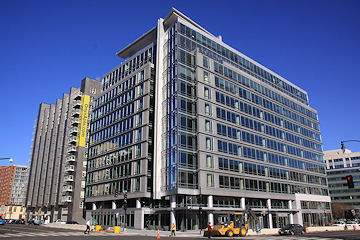 While everyone continues to nervously eye the commercial real market, Opus East has continued to sign tenants at 100 M Street. In addition to Parsons (who signed for 30 percent of the building's space early on), deals have now been completed with Battelle's transportation group (about 6,000 sq ft) and NAVSEA contractors CDI Marine (6,000 sq ft) and Orbis (7,400 sq ft). This brings the building to about 43 percent leased, according to Opus, with contracts closed to be completed for another 8,000 sq ft.
As for retail, SunTrust is still planning to open a branch there (perhaps as early as this spring, but nothing's confirmed), and Opus continues to look for a restaurant (or restaurants) to fill the remaining 8,500-sq-ft of ground-floor retail space.
|
Comments (0)
|
While it's outside of my jurisdiction to blog about what the Nationals do to further their goals of winning baseball games, I do consider it part of my mandate to keep an eye on that big building they hang out in. So, with that, here's some hints for what will be coming at the ballpark in 2009, from Chico Harlan's transcript of Stan Kasten's remarks at NatsFest:
* There will be big changes to the Red Porch restaurant in centerfield, which was the last part of the ballpark completed ("We literally got it the day before the season opened," Stan said). Here's how he describes what's coming: "What's gonna happen there is the walls you see now out there where it says Red Porch are being blow[n] out, and it's going to open up right into the ballpark with tables out into the stands. The other wall into the plaza is being blown out; we're having the patio with seats on the plaza with a firepit out there. And of course we're changing the floors and the walls and the menu, so it's going to be a much different experience."
* A stage will be coming to centerfield to allow for more pre-game activities, including the MASN live pre-game show, and some other "surprises" that will be announced later.
* Status of Josh Gibson, Walter Johnson, and Frank Howard will be erected in the centerfield plaza by Opening Day or soon thereafter.
* There will be changes to the food prep/service/quality, presumably in line with the change from concessionaire Centerplate to Levy Restaurants. Stan says: "We're going to have more in the way of value meals this year, because we know the budget is something everyone is worried about." [To which the audience applauded, according to the transcript.] "We're gonna tinker with some all-you-can-eat sections on certain nights; this has become popular in other cities. We're going to try experimenting with it ourselves this year."
* There will also be more specialty ticket packages for certain sections, which weren't spelled out. (The Nats have already announced lower ticket prices for many seats in the park this year.)
|
Comments (0)
More posts:
Nationals Park
|
From a press release just out, word that EYA will be seeking LEED for Homes certification for Capitol Quarter: "The neighborhood's proximity to public transportation, employment centers, parks and neighborhood retail reduces the amount of time homeowners spend in their cars. Add to that environmentally friendly building materials such as Energy Star appliances and windows, water saving plumbing fixtures, high efficiency heating and cooling equipment, and low VOC paints and finishes. The homes at Capitol Quarter provide more energy savings, better indoor air quality, and less impact on the environment than standard new townhomes -- all qualities that the LEED for Homes program is designed to promote." Also from the release, this: "Traditionally, LEED certification has been sought by builders for commercial buildings and custom residential homes. Capitol Quarter will serve as a model for volume builders in how to implement LEED for Homes on a larger scale."
UPDATE: Here's the release on EYA's site, which reminds me to note that this will be the largest LEED for Homes development in the country.
|
Comments (0)
More posts:
Capper, Capitol Quarter
|
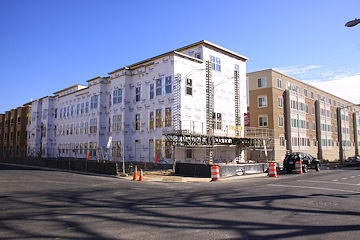
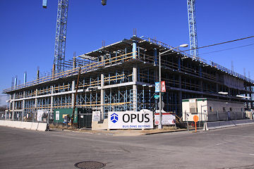
I took a nice tour of the action spots around the neighborhood today, getting updated photos of the very showy progress at Capitol Quarter and 1015 Half Street.
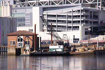 I also snuck across the river (don't tell) to get a peek through my zoom lens at the goings-on at Diamond Teague Park, plus I took a photo or two through the fence at First and Potomac. It looks like the gangplank from the shore to the pumphouse has been dismantled; and there's definitely "in-water" work going on.
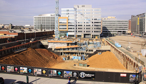
I also got a good batch of updated photos for 55 M, and gave my Monument Half Street page a badly needed refreshing--there's also this shot of the construction on the extension of the underground garage (and the shored-up hole on the south end of the block), as seen from Nats Parking Garage B.
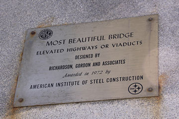 I even took my first(!) set of photos at 11th and L, where the Southeast Freeway bends toward the 11th Street Bridges, to get an official "before" baseline in advance of the reconstruction and reconfiguration of it all. (And I found this plaque on one of the flyover pillars, which might be worth a chuckle or two.)
If you want to see the entire batch of new photos on a single page, here they are, though it's about a hundred of them so be patient. But the links above are better if you want to see them matched with their "before"s.
(Oh, and that dinky little For Sale sign at 10th and M by the Exxon that I wrote about on Friday is gone. Drunken property advertising?)
|
Comments (0)
More posts:
1015 Half, 55 M St., Capper, Capitol Quarter, Monument Valley/Half St., square 697, Teague Park
|
I wasn't able to stay for a real long time, but I did take a few photos from the first hour or so today's first NatsFest at Nationals Park. Looks like they had a really good turnout, judging especially by the lines for autographs.
|
Comments (0)
More posts:
Nationals Park
|
Some items from the past few days. Big ones first:
* It's probably been true for weeks, but I've just now been by Diamond Teague Park for the first time in a while and can confirm that construction is definitely underway there. Fences are up, cranes (three of them?) are in place, and workers were there. Pictures tomorrow. (Probably *lots* of pictures tomorrow from all over, as long as the weather stays reasonably clear.)
* City Paper got its hands on the letter Mayor Fenty sent to DC Delegate Norton about the city's priorities should the Feds decide to toss some stimulus package dollars in this direction. As I predicted, the two Near Southeast bridge projects were mentioned: "In particular, aspects of the Eleventh Street and South Capitol Street Bridge replacement projects could be undertaken immediately." He also mentions the city's backlog of maintenance projects, along with investments in Metro and the implentation of the streetcar project. And school modernization. And public safety issues.And environmental initiatives. And housing affordability. And health care. (And now here's the stimulus bill itself, though it doesn't get down into specific projects. On the other hand, considering these two bridges ease the commutes to and from the district of the House Majority Leader....)
* Back in mid-November, the transfer of the plot of land known as Reservation 17A from the Feds to the city finally took place; it runs between New Jersey Avenue and Second Street, and is straddled by the trash transfer station building. With this now under District control, various wheels can start turning in that area, including allowing the establishment of I Street between Second and New Jersey that will form the southern boundary of WC Smith's 800 New Jersey Avenue project. There's hopes that the trash transfer station could be demolished in 2010.
* Reader T. reported yesterday that a small bought-at-the-hardware-store For Sale sign went up at 10th and M yesterday, in front of the fence of the Exxon station. I'm not sure what the deal is, since the land is actually owned by the Exxon Corporation, and you'd think they'd have better methods of marketing the land.
* The public notice for the March 19 Zoning Commission hearing on various Capper PUD alteration requests is now available.
* WBJ reports that the Nationals have parted ways with Centerplate, last year's concessionare at the ballpark. This year it will be Levy Restaurants for the food and Facility Merchandising Inc. for the retail.
* More of the fences are coming down at 55 M, as you can see on the web cam. (Though it took me more than a month to notice that the plywood "tunnel" at the Metro exit had disappeared.)
* The Douglass Bridge will be closed at 5 am Sunday until 10am-ish to test the swing span.
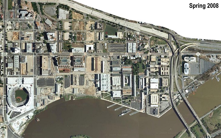 I've been waiting for this for a good while: sometime in the past few weeks, Google Maps updated its satellite images of Near Southeast, after having been stuck in 2004 time-range for a long time. It's now a shot from sometime in Spring of 2008 (May or late April, to judge by the work on the hole at 1015 Half Street and the leafy-ness of the trees at the ballpark), and, lo and behold, there's that Nationals Park, all shiny and new.
There's been other free online satellite images that were more recent than Google's, but the newest I had seen was this Mapquest shot from late 2006, where the steel work was underway at the ballpark. So this is quite a Great Leap Forward, not only because it shows the completed ballpark, but comparing the two images (as you can do on my Satellite Compare page) shows the incredible amount of change during that 18-month timespan in the neighborhood. (You can also compare this newest images to others from 1988, 2002, 2004, and 2005; my preference is to compare it to 2002.)
|
Comments (0)
More posts:
Nationals Park
|
It's a few days behind schedule, but I've finally completed my 2009 State of the Hood roundup, where I take a few minutes (and a heck of a lot of words) to look back at what happened in 2008 and what's on tap (or, more realistically, not on tap) for 2009. If you haven't been following along closely (and I'm not sure who really does other than me anymore), this is a good way to get caught up on what's under construction, what's finishing up, and what's to come. (If you want some quick numbers, there's also my Development Since 1999, By the Numbers chart.)
The short version for 2008?
First half: All Nationals Park all the time.
Second half: Hello, is there anybody out there?
(On the bright side, this second part is pretty much the same story in any neighborhood anywhere in the country.)
As for 2009, at this point it's hard to imagine a whole lot of projects getting started, though if the economy starts to perk up in the second half of the year there could be some movement. (I'm no Dr. Doom, but you can still color me a bit skeptical.) I haven't put up the Gone Fishin' sign yet, but clearly the volume of JDLand content is going to continue to be a bit thin for a while.
And, while my expertise in predicting the ups and downs of the commercial real estate biz is somewhere around, um, none, I'll still pat myself on the back for this final paragraph from my 2008 SOTH: "Near Southeast will make its official debut with quite a splash in 2008, but we'll also find out whether the economy will slow down the blistering revitalization pace the neighborhood saw in 2007. And whether the Nats can christen their new home with a postseason run. And whether I can make it through to 2009." Well, two out of three ain't bad.
|
Comments (0)
More posts:
|
Pulling together some reminders and other recent Twittered tidbits:
* This Sunday is NatsFest at the ballpark, from 1 pm to 5 pm. It's being held indoors in the various club areas, so if you've never gotten to see some of the lounges, or the conference center, or the clubhouse, this might be a good opportunity. Season-ticket holders get four free tickets; for the rest of the world it's $10 for adults and $5 for children under 12.
* Last week a raze permit was issued for the defunct Wendy's on I Street. No word on when demolition will actually occur. This is where JPI is planning its fourth Capitol Yards apartment building, 23 I Street, but there's been no recent intelligence on when they might decide to get underway.
* Construction hasn't yet begun on the Park at the Yards, but some additional information and more detailed renderings should be coming to light over the next month. Forest City is scheduled to make presentations to the National Capital Planning Commission on Feb. 5, and the Commission on Fine Arts on Feb. 16, and possibly ANC 6D on Feb. 9.
* A reader is reporting this morning that a derrick crane is going up at Diamond Teague Park--perhaps that's to begin work on the water taxi piers. (Though note that there was already a crane of some sort there back in December when I took these photos.)
* Apparently the various property owners surrounding the section of Eighth Street south of the freeway have gotten together along with the Capitol Riverfront BID to start working on plans to perk up the area, using the Connect Barracks Row report by University of Maryland Urban Studies and Planning students as a jumping-off point. Look for public meetings in February-ish.
I haven't seen it with my own eyes yet, but a couple readers reported yesterday (as I Twittered) that Capitol Quarter vertical construction has now begun on the north side of L Street between Fourth and Fifth, across from the units already well underway. (There's also a rumor that bricking will begin on those first townhouses soon.) The foundations have been underway on this block for a while, so I'm assuming it's the showier framing work that has begun. I'll give them a day or two to make some progress, and will get photos this weekend.
|
Comments (0)
More posts:
Capper, Capitol Quarter
|
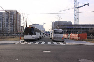 It's not terribly exciting to look at photos of parked buses, but if you want to see a couple shots of what Near Southeast looked like on Tuesday, here's a few pictures. (You'll also see there a sprinkling of images of 1015 Half Street, now four stories high.) I left the Hill around 9:30 am and walked down south of the Freeway, crossing into Southwest on I Street, and inhaling all manner of bus fumes (from illegally idling vehicles) along the way. I then followed the mobs westward along Independence (since the Mall was closed off before I even left home) and ended up at one of the Jumbotrons along 17th Street near the World War II Memorial. From there, it was an easy trip back homeward along Maine Avenue to I Street.
 For all of the hassles that now are part of living on Capitol Hill, a day like yesterday reminds one of its benefits, since the Metro or bus rides or parking were not part of my day--just 5 1/2 miles of walking. My only regret of the day is that I didn't follow the brave souls who took the ramp up onto the SE/SW Freeway to cross toward RFK--it would have been my one chance to get photos from the freeway without being in a speeding car!
If you want to see additional photos of my inauguration trek (with a number from Southwest), here they are, though note that they are in reverse chronological order.
UPDATE: And, just so that people don't think I'm praising life on the Hill at the expense of the other close-in spots, I'll note that a day like yesterday also shows the benefits of living in Near Southeast or Southwest. (You folks in close-by neighborhoods north of the parade route, though, didn't get to live the good life like the south-of-the-Mall-ers did, unless you really enjoyed that trek through the Third Street Tunnel.)
|
Comments (0)
More posts:
|
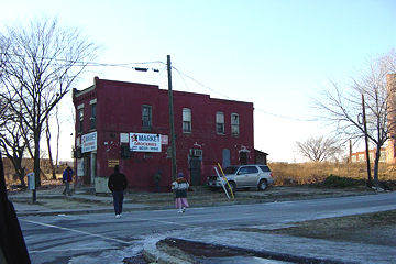 On January 19, 2003, I decided to take a bunch of photos of the area south of the Southeast Freeway, and then came home and posted them on my personal web site. No grand plans for hyperlocal journalism or neighborhood blogging--I'd just heard there were plans to revitalize the neighborhood (even though I didn't even know what the area was called), and wanted to have a few pictures of what it looked like "before." And then I created a page of links for myself so that I could keep an eye on the various projects without having to dig through my bookmarks.
There's too much going on in the city right now to really pay much attention to this little anniversary, but I couldn't let it go by completely unmarked. I'll look back over the past year and look ahead at what's {probably not} coming in 2009 within the next few days, but until then, Happy Anniversary to me. And a big thanks to everyone who reads the site and who send tips or feedback--this site never would have grown into the monstrosity it's become if I hadn't discovered that people were actually interested in what was being posted.
(And, as a useless aside: astute observers might note that I'm not marking the anniversary of JDLand.com--that's because I've had a JDLand web site since 1996, containing several different online projects of which Near Southeast DC blogging was just one. The root JDLand.com address only became the official Near Southeast web site in 2007, when I finally figured out this particular project was a bigger draw than,say, photos of our kitchen remodel.)
|
Comments (0)
More posts:
|
2006 Posts:
Go to Page: 1 | 2 | 3 | 4 | 5 | 6 | 7 | 8 | 9 | 10 ... 201
Search JDLand Blog Posts by Date or Category
Go to Page: 1 | 2 | 3 | 4 | 5 | 6 | 7 | 8 | 9 | 10 ... 201
Search JDLand Blog Posts by Date or Category


