
|
| |||||||||||||||||||

|
Please note that JDLand is no longer being updated.
JDLand.com Search
- Full Neighborhood Development MapThere's a lot more than just the projects listed here. See the complete map of completed, underway, and proposed projects all across the neighborhood.
- What's New This YearA quick look at what's arrived or been announced since the end of the 2018 baseball season.
- Food Options, Now and Coming SoonThere's now plenty of food options in the neighborhood. Click to see what's here, and what's coming.
![-]()
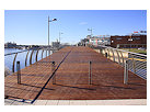
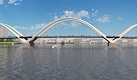
- Anacostia RiverwalkA bridge between Teague and Yards Parks is part of the planned 20-mile Anacostia Riverwalk multi-use trail along the east and west banks of the Anacostia River.
![-]()
- Virginia Ave. Tunnel ExpansionConstruction underway in 2015 to expand the 106-year-old tunnel to allow for a second track and double-height cars. Expected completion 2018.
![-]()
- Rail and Bus Times
Get real time data for the Navy Yard subway, Circulator, Bikeshare, and bus lines, plus additional transit information. - Rail and Bus Times
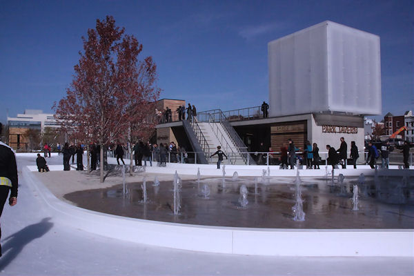
Get real time data for the Navy Yard subway, Circulator, Bikeshare, and bus lines, plus additional transit information. - Canal ParkThree-block park on the site of the old Washington Canal. Construction begun in spring 2011, opened Nov. 16, 2012.
![-]()
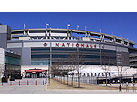
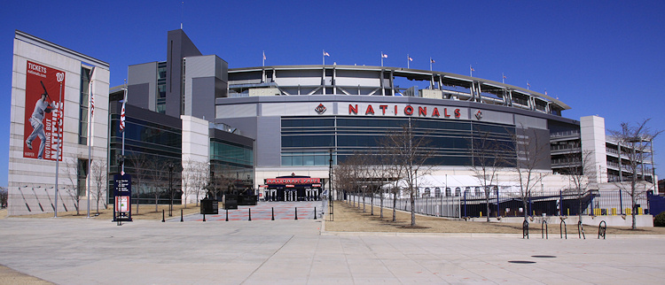
- Nationals Park21-acre site, 41,000-seat ballpark, construction begun May 2006, Opening Day March 30, 2008.
![-]()
- Washington Navy YardHeadquarters of the Naval District Washington, established in 1799.
![-]()
- Yards Park5.5-acre park on the banks of the Anacostia. First phase completed September 2010.
![-]()
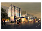
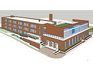
- Van Ness Elementary SchoolDC Public School, closed in 2006, but reopening in stages beginning in 2015.
![-]()
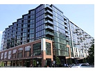
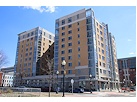
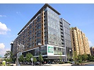
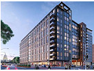
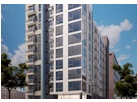
- Agora/Whole Foods336-unit apartment building at 800 New Jersey Ave., SE. Construction begun June 2014, move-ins underway early 2018. Whole Foods expected to open in late 2018.
![-]()
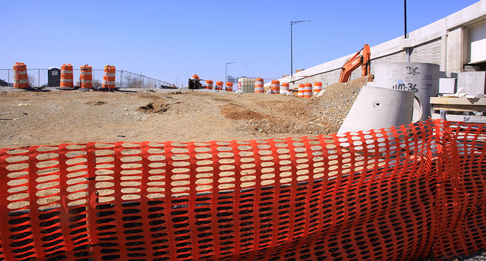
- New Douglass BridgeConstruction underway in early 2018 on the replacement for the current South Capitol Street Bridge. Completion expected in 2021.
![-]()
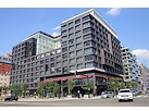
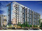
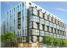
- 1221 Van290-unit residential building with 26,000 sf retail. Underway late 2015, completed early 2018.
- NAB HQ/AvidianNew headquarters for National Association of Broadcasters, along with a 163-unit condo building. Construction underway early 2017.
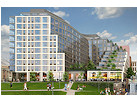
- Yards/Parcel O Residential ProjectsThe Bower, a 138-unit condo building by PN Hoffman, and The Guild, a 190-unit rental building by Forest City on the southeast corner of 4th and Tingey. Underway fall 2016, delivery 2018.
- New DC Water HQA wrap-around six-story addition to the existing O Street Pumping Station. Construction underway in 2016, with completion in 2018.
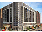
- The Harlow/Square 769N AptsMixed-income rental building with 176 units, including 36 public housing units. Underway early 2017, delivery 2019.
- West Half Residential420-unit project with 65,000 sf retail. Construction underway spring 2017.
![-]()
- Novel South Capitol/2 I St.530ish-unit apartment building in two phases, on old McDonald's site. Construction underway early 2017, completed summer 2019.
![Novel South Capitol]()
- 1250 Half/Envy310 rental units at 1250, 123 condos at Envy, 60,000 square feet of retail. Underway spring 2017.
![-]()
- Parc Riverside Phase II314ish-unit residential building at 1010 Half St., SE, by Toll Bros. Construction underway summer 2017.
![-]()
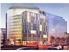
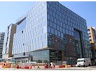
- 99 M StreetA 224,000-square-foot office building by Skanska for the corner of 1st and M. Underway fall 2015, substantially complete summer 2018. Circa and an unnamed sibling restaurant announced tenants.
![-]()
- The Garrett375-unit rental building at 2nd and I with 13,000 sq ft retail. Construction underway late fall 2017.
![-]()
- Yards/The Estate Apts. and Thompson Hotel270-unit rental building and 227-room Thompson Hotel, with 20,000 sq ft retail total. Construction underway fall 2017.
![-]()
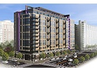
- Meridian on First275-unit residential building, by Paradigm. Construction underway early 2018.
![-]()
- The Maren/71 Potomac264-unit residential building with 12,500 sq ft retail, underway spring 2018. Phase 2 of RiverFront on the Anacostia development.
![-]()
- DC Crossing/Square 696Block bought in 2016 by Tishman Speyer, with plans for 800 apartment units and 44,000 square feet of retail in two phases. Digging underway April 2018.
![DC Crossing]()
- One Hill South Phase 2300ish-unit unnamed sibling building at South Capitol and I. Work underway summer 2018.
![One Hill South Phase 2]()
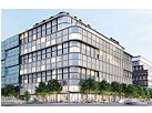
- New DDOT HQ/250 MNew headquarters for the District Department of Transportation. Underway early 2019.
![New DDOT HQ]()
- 37 L Street Condos11-story, 74-unit condo building west of Half St. Underway early 2019.
![37 L Condos]()
- CSX East Residential/Hotel225ish-unit AC Marriott and two residential buildings planned. Digging underway late summer 2019.
![CSX East Residential/Hotel]()
- 1000 South Capitol Residential224-unit apartment building by Lerner. Underway fall 2019.
![1000 South Capitol Residential]()
- Capper Seniors 2.0Reconstruction of the 160-unit building for low-income seniors that was destroyed by fire in 2018.
![1000 South Capitol Residential]()
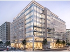
- Chemonics HQNew 285,000-sq-ft office building with 14,000 sq ft of retail. Expected delivery 2021.
![1000 South Capitol Residential]()


Search term: (11bridges) : 159 matching blog entries
Thursday Tidbits: Las Placitas, Navy Yard Items, South Park
Oct 15, 2015 9:50 AM
 * LOWER LAS PLACITAS: Capitol Hill Corner reports that the owners of Las Placitas told ANC 6B that they hope to open in their new location at 8th and L Streets SE on Nov. 1. The space will have 40 seats inside and another 38 along the building's north side.
* 'CAPERS: Excerpts from the one-woman play "'Capers," about how residents of Capper/Carrollsburg dealt with the housing project's demolition, is being performed tonight (Oct. 15) at 7 pm at 400 M St. SE, hosted by the Arthur Capper Carollsburg Community Village. You can also catch the entire play four nights next week at the Forum Theatre in Silver Spring.
* DSS BARRY CEREMONY: The Display Ship Barry isn't actually leaving just yet, but on Saturday Oct. 17 the Navy is holding a departure ceremony at 10 am inside the fences of the Navy Yard. See the announcement for details, including how to get into the base if you wish to attend. It was announced in February that the ship will be dismantled and removed from its home along the Anacostia Riverwalk.
* WATCH. BOX.: A "watch box" (guard shack) that stood as part of the sentry post at the Navy Yard's 8th Street entrance from 1853ish until 1905ish and was passed through by Abraham Lincoln just hours before his assassination has been restored and formally ribbon-cut on Oct. 8 after its return earlier this year from a 110-year stay at Indian Head. (Though unfortunately it's on display on a portion of the grounds that most of us will never see.)
 The clear skies were just perfect this weekend, and so I ended up walking a whole lot of miles and taking a whole lot of photos on both Saturday and Sunday--including a new "official" JDLand Nats Park portrait, as you see, where I also inadvertently caught the former centerfield plaza statues in their new home.
* SODOSOPA: South Park took on gentrification last week, with the new neighborhood of SoDoSoPa, the Lofts at SoDoSoPa, and the Residences at the Lofts at SoDoSoPa. And there was this: "What this town needs is a Whole Foods. It will instantly validate us as a town that cares about stuff." (And yet you people still refuse to adopt my new name for this neighborhood, Near Capitol Ballpark River Yards, #NeCaBaRY.)
* BRIDGE BEFORE AND AFTER: DDOT's historic photos Tumblr recently included a shot from 1966 of the early construction of the downriver 11th Street Bridge span. And I realized I have a photo taken from a very similar location as the span was dismantled in 2012 and its offspring was built. (The piers remain in the water, though, as the potential underpinnings of the 11th Street Bridge Park.)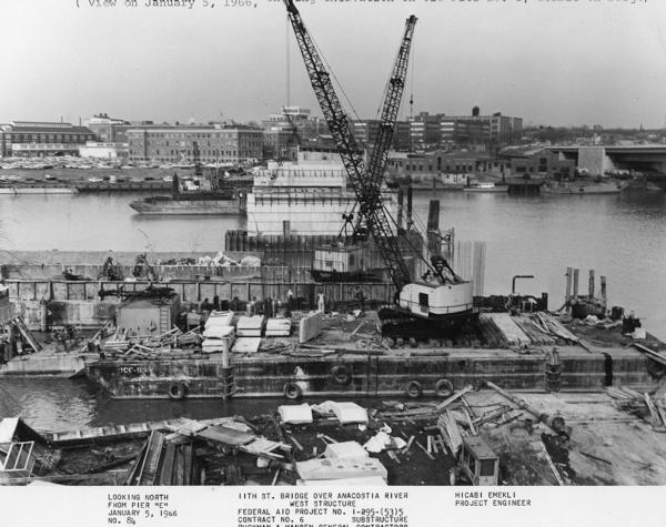


Comments (5)
More posts:
11th Street Bridges, barry, Capper, 8th Street, Restaurants/Nightlife, lasplacitas, Navy Yard
Tuesday Tidbits: All Over the Map
Mar 31, 2015 10:59 AM
 The clear skies were just perfect this weekend, and so I ended up walking a whole lot of miles and taking a whole lot of photos on both Saturday and Sunday--including a new "official" JDLand Nats Park portrait, as you see, where I also inadvertently caught the former centerfield plaza statues in their new home.
 * ALL-STAR GAME: The rumors keep flying that Nationals Park will be the site of the 2018 Major League Baseball All-Star Game, but when Tom Boswell says he is "virtually certain" he will be happy with the 2018 announcement when it is made, well, one does take notice. Official word could come on April 6, when new commissioner Rob Manfred comes to Nationals Park to throw out the Opening Day first pitch.
* NLRB MOVE DELAYED: There's been some wondering about when the National Labor Relations Board will arrive at 1015 Half Street, and WBJ has the story of the "costly planning snafu" that delayed the move by six months (it looks like late June may now be the date).
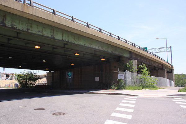
* 11TH STREET BRIDGES VERSION 1.0: DDOT's latest dive into its photo archives includes a shot of the construction of the highway version of the 11th Street Bridges, back in 1964, before there was a highway to connect them to. It also shows the original "local" bridge.
* 503 ERRORS: I know that the site is throwing "503 Service Unavailable" errors with some frequency these days. I'm begging the hosting company to get them fixed, but in the meantime, at least the errors generally never last more than a few seconds. Count to 10 and hit refresh, and your requested page should appear (though then sometimes it takes a little longer for images and formatting to return). UPDATE: And then the site took a breather for an hour early this afternoon, which seemed to finally get the attention of the hosting folks, though I think there are still all manner of configuration issues that they need to fix. Why this has to happen in March and not December, I don't know....
Comments (1)
More posts:
1015 Half, 11th Street Bridges, Nationals Park
Tuesday Tidbits: What's in a Name, Anyway?
Mar 3, 2015 9:15 AM
Catching up a bit:
* CHEF SCOUTING: Master chef Peter Chang and his partners are "looking in the Capitol Riverfront neighborhood for a 6,000-square-foot space that could, when finished, serve as Chang's fine-dining flagship." He is about to open restaurants in Rockville and Arlington, alongside his existing Richmond and Charlottesville offerings that all showcase his "genuine, flame-throwing Sichuan cooking" considered to be some of the best Chinese food in the country. However, given that the word "peripatetic" is often used to describe him, we'll see what happens. (WaPo)
* FESTIVAL FESTIVALING: The National Cherry Blossom Festival will close this year with a new event, the Anacostia River Festival, on April 12 from noon to 4 pm at Anacostia Park. A joint effort by the 11th Street Bridge Project and the National Park Service, it is expected to feature boating, fishing workshops, tours of historic Anacostia, and "other unique programs to engage families with the environment."
* POOL CLUBBING: VIDA's Penthouse Pool Club opens on May 1. Assuming it has stopped snowing by then.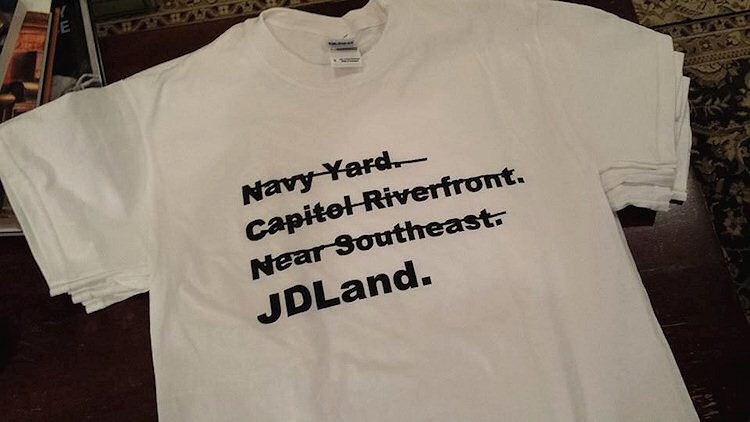 * AHEM: I've referenced this in a few unofficial places, but might as well just give it the full-on treatment. Recently Mr. JDLand was struck by a creative bolt of lightning (or perhaps was just tired of listening to me rant and rave), and presented me with the design at left. With tongue most firmly in cheek, I admit it cracks me up. If you would like to be among those making such a bold statement, the shirts are $12, available in S-M-L-XL. An in-person hand-off can probably even be arranged if you live within the general JDLand listening area. Shoot me a message if you are interested.
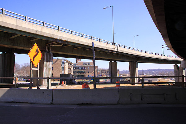
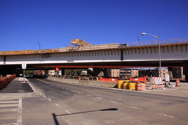
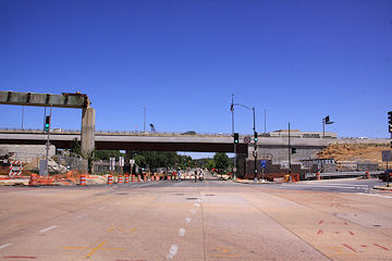
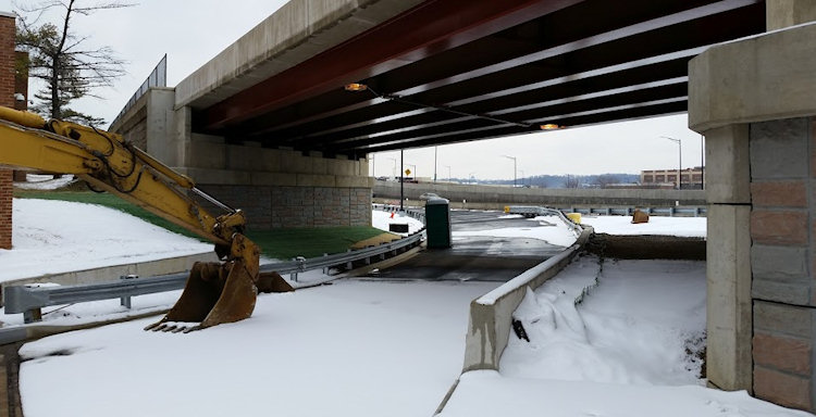 It looks like the exit ramp to 8th Street SE from westbound I-695 (inbound from the 11th Street Bridges) that has been MIA in recent months may soon be back in business.
 * AHEM: I've referenced this in a few unofficial places, but might as well just give it the full-on treatment. Recently Mr. JDLand was struck by a creative bolt of lightning (or perhaps was just tired of listening to me rant and rave), and presented me with the design at left. With tongue most firmly in cheek, I admit it cracks me up. If you would like to be among those making such a bold statement, the shirts are $12, available in S-M-L-XL. An in-person hand-off can probably even be arranged if you live within the general JDLand listening area. Shoot me a message if you are interested.
Comments (5)
More posts:
11th Street Bridges, bridgepark, Events, Restaurants/Nightlife, peterchang, JDLand stuff, vida
I-695 Ramp to 8th Street On its Way Back from a Year's Sabbatical
Feb 26, 2015 3:14 PM
 It looks like the exit ramp to 8th Street SE from westbound I-695 (inbound from the 11th Street Bridges) that has been MIA in recent months may soon be back in business.
DDOT announced on Wednesday that it will be reducing I Street SE to one lane between 9th and 10th streets through the end of March so that they can "install a raised median island and accommodate the new free flow exit ramp connection currently under construction from westbound I-695 to 'Eye' Street, SE." 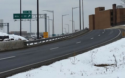 This resulted in tasking my errand boy with some snowy photography, of not only the ramp itself (above), but also a hard-to-get shot of the new exit sign, surprisingly uncovered, on the freeway. You can see that the new exit goes underneath the no-longer-new ramp from 11th Street SE to the westbound freeway.
 There's been a lot of weekend closures along 11th Street SE in the past few years, thanks to the 11th Street Bridges project, but this upcoming one is probably a little more disruptive than the others:
 This resulted in tasking my errand boy with some snowy photography, of not only the ramp itself (above), but also a hard-to-get shot of the new exit sign, surprisingly uncovered, on the freeway. You can see that the new exit goes underneath the no-longer-new ramp from 11th Street SE to the westbound freeway.
Also sayeth DDOT: "Upon completion of the construction, the street will be reopened in the final configuration with one lane westbound between 9th Street, SE, and 10th Street, SE. Modifications will also include improved safety features for pedestrians and the removal of rush-hour parking restrictions along this stretch."
The advisory did not give a date for the opening of the exit, which was closed nearly a year ago, at which point the scary flyover with the huge curve that led to the exit ramp was mercifully demolished.
Comments (1)
More posts:
11th Street Bridges, Traffic Issues
Closures of 11th and M SE Intersection Planned for This Weekend
Oct 29, 2014 1:52 PM
 There's been a lot of weekend closures along 11th Street SE in the past few years, thanks to the 11th Street Bridges project, but this upcoming one is probably a little more disruptive than the others:
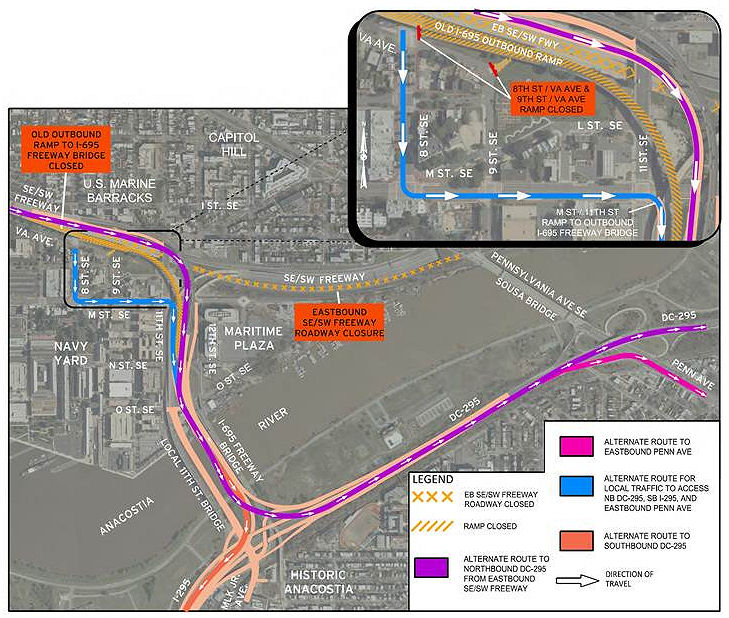
"As part of the 11th Street Bridge project, the District Department of Transportation (DDOT) will close the intersection of 11th Street, and M Street, SE from 6:00 AM to 9:00 PM on both Saturday, November 1, 2014 and Sunday, November 2, 2014.
"The westbound I-695 (Southeast/Southwest Freeway) exit ramp to M Street, SE and the on-ramp to southbound I-295/northbound DC 295 at M Street, SE will also be closed during these times.
"The closures will allow crews to complete milling operations at the intersection in preparation for final paving and striping.
"During the intersection closures, temporary signs and traffic control measures will be in place to alert and guide the traveling public around the work zone."
{emphasis mine, along with some improved paragraph breaks. Here's the official release.}
It also would seem to mean that, for all intents and purposes, use of the 11th Street Local bridge will be hampered considerably as well, since it's pretty much required that vehicles use 11th and M to get to or from that bridge.
The wording also telegraphs that there will be another closure still to come for the actual paving, which DDOT tells me has not yet been scheduled.
This also means that my plans to do a big post about all the changes along 11th Street north of M using photos that are now three weeks old will probably just wait until after this work is done.
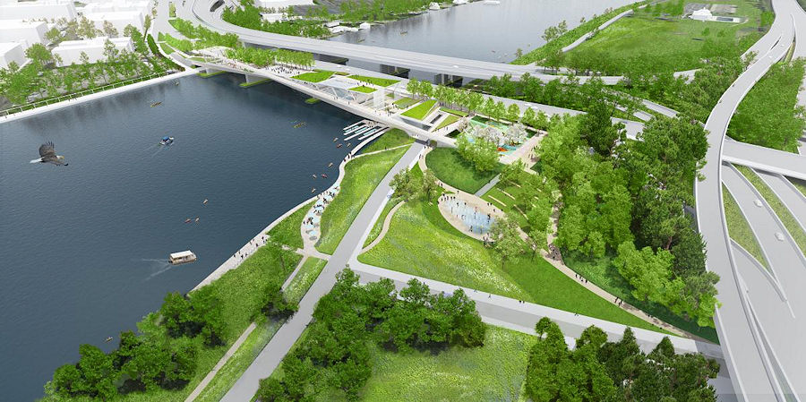 It was announced this morning (well, last night, actually) that the 11th Street Bridge Park's design competition has been won by "Anacostia Crossing," from the team of the Office of Metropolitan Architecture (OMA) and Olin Studio.
UPDATE: So, perhaps DDOT's use of the phrase "close the intersection" is a bit of overkill--in an exchange of e-mails trying to pin down the ability to access the 11th Street Local bridge, I was told that the milling operation will be staged such that traffic can be routed "around the work."
I'd still stay away if at all possible.
Comments (0)
More posts:
11th Street Bridges, Traffic Issues
OMA/Olin Design Chosen for 11th Street Bridge Park
Oct 16, 2014 10:43 AM
 It was announced this morning (well, last night, actually) that the 11th Street Bridge Park's design competition has been won by "Anacostia Crossing," from the team of the Office of Metropolitan Architecture (OMA) and Olin Studio.
OMA/Olin designed a park in "a sloping 'X' shape" over both the river and the banks on its eastern side. Features include a central plaza, a café, boat launches, an amphitheater, and "a series of nets that would allow people to dangle out over the river."
One competition juror described the design thusly: " 'It is at once both a crossing and place. In its purest role it is a hyphen that connects and celebrates the physical and cultural histories of two historic and vibrant Anacostia shoreline communities, while establishing a civic expression of democracy.' "
The Washington Post has a video rendering of the park design, in addition to the many renderings available on the official web site.
As always, however, the looming question remains the full funding of the park's $40 million price tag. As explained by the Post, "The D.C. government has committed to providing $14.5 million of the $25 million construction price tag[.] An additional $15 million would provide operations funding." A capital campaign is underway to fund that $25 million difference. So, needless to say, construction won't be starting next week.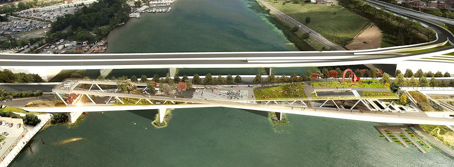


Officially Snapshotting the (Somewhat) New 11th Street Exit Ramp
Jul 19, 2014 1:40 PM
Despite it being four weeks after the fact, JDLand's strict operating requirements still dictate that I document the new exit ramp to 11th Street SE from eastbound I-695.
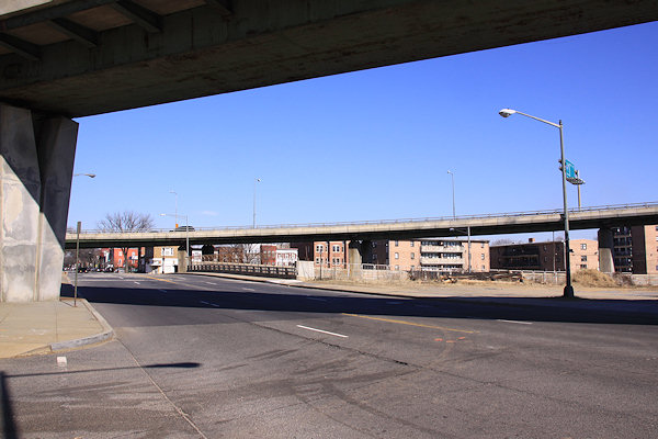
With thanks to Mr. JDLand for chauffeuring, here's what it's like to venture along this new route, if you haven't done it. (And sure, I could have Vined it, or YouTubed it, or whatever, but what fun would that be?)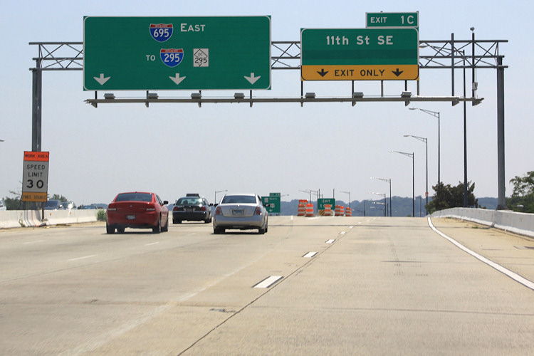 The view driving east on the Southeast Freeway (which is now I-695, if you haven't gotten the memo). If you always get off at or before the 6th Street SE exit, this may be an unfamiliar vista to you. The left lanes head toward the outbound 11th Street Bridges, while the right two lanes are the new movement that didn't exist before this whole project got underway. (And is that hidden part of the 11th Street sign maybe an eventual pointer to Southeast Blvd.?)
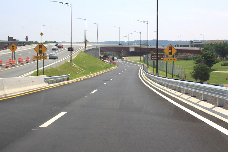 Behold, the new ramp! You also get to see the two new flyovers at left that have been built as part of this project, which has been underway since 2009. Sneaking up in between is the new on-ramp from 8th Street SE, which opened not long ago. At right is Virginia Avenue Park. Note also the sign pointing toward Anacostia Park--this would take you down 11th to the new local bridge and to the park that-a-way.
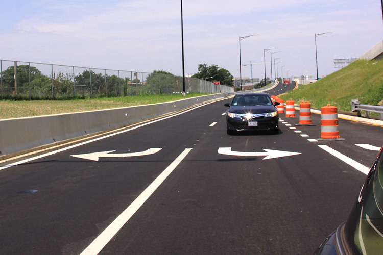
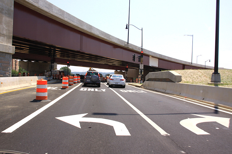 And now you come to the intersection at 11th. Turning left takes you north toward Pennsylvania Avenue and Lincoln Park, while turning right takes you to M Street, the Navy Yard, and the local bridge. Note the blocked-off third lane that is striped for left turns as well--I assume there will come a time when the middle lane will be for traffic continuing straight on Southeast Blvd.
 Wrapping up our little journey, here's a quick look backward at the road just traveled.
The view driving east on the Southeast Freeway (which is now I-695, if you haven't gotten the memo). If you always get off at or before the 6th Street SE exit, this may be an unfamiliar vista to you. The left lanes head toward the outbound 11th Street Bridges, while the right two lanes are the new movement that didn't exist before this whole project got underway. (And is that hidden part of the 11th Street sign maybe an eventual pointer to Southeast Blvd.?)Behold, the new ramp! You also get to see the two new flyovers at left that have been built as part of this project, which has been underway since 2009. Sneaking up in between is the new on-ramp from 8th Street SE, which opened not long ago. At right is Virginia Avenue Park. Note also the sign pointing toward Anacostia Park--this would take you down 11th to the new local bridge and to the park that-a-way.And now you come to the intersection at 11th. Turning left takes you north toward Pennsylvania Avenue and Lincoln Park, while turning right takes you to M Street, the Navy Yard, and the local bridge. Note the blocked-off third lane that is striped for left turns as well--I assume there will come a time when the middle lane will be for traffic continuing straight on Southeast Blvd. Wrapping up our little journey, here's a quick look backward at the road just traveled. Need a reminder of what this spot used to look like? Remember the phrase "sunken freeway"? Here's a reminder, from street level and from above.
 I already wrote about how this Saturday, June 21, is the target date for DDOT to open the new ramp from eastbound I-695 to 11th Street, SE. (Yay!)


And, because I am a complete nutcase (which we already knew), here is a bunch of photos--strung together as a slideshow--that I took just as the 11th Street Bridges project was getting underway in early 2010, showing what it used to be like to drive across the Anacostia on that route. Apologies for the dirty windshield.
(I know, my archive just gets more and more alarming.)
Comments (3)
More posts:
11th Street Bridges, Southeast Blvd., Traffic Issues
This Week in Traffic: 11th St. Ramp Closings/Openings, M Street
Jun 17, 2014 8:18 AM
 I already wrote about how this Saturday, June 21, is the target date for DDOT to open the new ramp from eastbound I-695 to 11th Street, SE. (Yay!)
But now there's a related closing to note: On June 21, DDOT will close the newish on-ramp from 11th Street SE to the westbound Southeast Freeway for two months, until approximately August 23.
This will allow the completion of the rebuilt exit to I Street from inbound I-695, which has been closed while the old flyover has been demolished.
If you're needing to get on the westbound freeway, you'll need to use the ramp at 3rd Street and Virginia Avenue, or the South Capitol Street ramp. (Or I guess you could go backwards and get on southbound DC-295 at Pennsylvania Avenue and take the Capitol Hill exit.)
 The next step in the 11th Bridges project is coming on or about June 21, when the new ramp down to 11th Street SE from the eastbound Southeast Freeway is scheduled to open.
Here's DDOT's advisory on that closing if you want to know more, or to see the pretty graphic with all the detour arrows. Meanwhile, the icky configuration of the eastern section of M Street thanks to DC Water's Clean Rivers Project is about to get ickier: Starting on or about Wednesday, June 18, through the end of the year, two eastbound M Street lanes between 7th and 11th Streets, SE will be closed 24/7, leaving two lanes of eastbound and two lanes of westbound traffic on M. Best to also expect some stoppages of traffic during the work hours of 7 am to 7 pm Monday through Saturday.
 Meanwhile, the icky configuration of the eastern section of M Street thanks to DC Water's Clean Rivers Project is about to get ickier: Starting on or about Wednesday, June 18, through the end of the year, two eastbound M Street lanes between 7th and 11th Streets, SE will be closed 24/7, leaving two lanes of eastbound and two lanes of westbound traffic on M. Best to also expect some stoppages of traffic during the work hours of 7 am to 7 pm Monday through Saturday.
You can read the DC Water advisory on the closure for more information.
Comments (3)
More posts:
11th Street Bridges, M Street, Traffic Issues
New Freeway Exit Ramp to 11th Street SE Opening June 21
Jun 5, 2014 12:06 PM
 The next step in the 11th Bridges project is coming on or about June 21, when the new ramp down to 11th Street SE from the eastbound Southeast Freeway is scheduled to open.
This means that folks on the eastern end of Capitol Hill will no longer have to get off at 6th Street and wind their way eastward--they will arrive at 11th just north of L, and can either turn left on 11th or right to the Navy Yard and across the 11th Street Local bridge to Anacostia.
 As you can see, If you rent one of the Twelve12 units on the north end of the building, you'll have a great view of the construction at the Lofts at Capitol Quarter.
The map at right provided by DDOT shows the various new movements that this new ramp will put on the table.
Coupled with the entrance ramp to the westbound freeway that opened a while back, 11th Street is now quite the access point for the Southeast/Southwest Freeway. And someday, it will be a full intersection that will include traffic traveling to or from Southeast Blvd., in whatever form that ends up taking.
Comments (4)
More posts:
11th Street Bridges, Traffic Issues
Thursday Tidbits: Plain White Concrete Sandlot
Jun 5, 2014 12:23 AM
 As you can see, If you rent one of the Twelve12 units on the north end of the building, you'll have a great view of the construction at the Lofts at Capitol Quarter.
 Now to the tidbits:
* The latest on the Xavier Cervera mess. (WSJ)
* Apparently there is a void that can only be filled by a PROFESSIONAL. (City Paper)
* The 11th Street Bridges project receives an Award of Excellence in Concrete from the National Capital Chapter of the American Concrete Institute. No, really. (Hill Rag)
* The Courtyard touts its makeover. (Press release via Yahoo)
* How does DDOT see the city's multimodal future evolving? Check out the MoveDC draft transportation plan.
And, on the agenda:
* On Thursday, the Nats play the Phillies at 4 pm, which clears the evening for the first NatsLive concert of the season, with the Plain White T's. The show is free for anyone with a ticket to the game, though there's no truth to the rumor that they will just play "Hey There, Delilah" 17 times in a row.
* Then at sundown the Capitol Riverfront Summer Outdoor Movie Series kicks off at the northern end of Canal Park with the Sandlot.
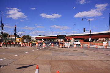
 The process continues to create the 11th Street Bridge Park, with the announcement on Tuesday of the four teams picked for the final stage of the design competition.
* On Friday, Sam O brings reggae to the Yards Friday Night Concert Series, starting at 6:30 pm.
* If you can think this far ahead, it's been announced that Snallygaster is returning to the Yards, on September 13. "An epic day of inimitable imbibery and monstrous merriment featuring over 200 craft drafts."
Comments (1)
Bridge Park's Final Four Design Teams Picked; Meet Them June 10
May 28, 2014 4:24 PM
 The process continues to create the 11th Street Bridge Park, with the announcement on Tuesday of the four teams picked for the final stage of the design competition.
The park, which will use the piers still standing after the demolition of the old outbound 11th Street Bridge, would create a new type of connection between the east and west sides of the Anacostia River, and is described by its supporters as "an iconic new civic space that will provide a unique venue supporting the community’s environmental, economic, cultural and physical health."
The design teams chosen are made up of landscape architects, architects, and structural engineers, and have been given $25,000 to create their submissions. The teams are:
• Balmori Associates / Cooper, Robertson & Partners / Guy Nordenson Associates
 * RESULTS: Last week I mentioned how concerned parents and neighbors were organizing a drive to call David Catania's office on May 1 to impress upon him the importance of opening Van Ness Elementary as scheduled in 2015. It didn't even take until the end of the day to get results, as evidenced by this quote sent to the Van Ness Parents Group from Catania's office: "[Councilmember Catania] supports the on-time opening and modernization of Van Ness. And while the Committee does not finalize and markup its budget until May 15th, it is the Councilmember’s intention to keep Van Ness’ $15 million FY15 renovation in the budget as proposed. Thank you again for your hard work and advocacy!"
• OLIN / OMA / Arup
• Stoss Landscape Urbanism / Höweler + Yoon Architecture / Robert Silman Associates
• Wallace Roberts & Todd (WRT) / NEXT Architects / Magnusson Klemencic Associates
The park's jury expected to choose a final design this fall.
And on June 10, members of the public will be able to hear from the four teams (one of which includes OLIN, designers of Canal Park) The event runs from 6:30 to 8 pm at THEARC, 1901 Mississippi Ave., SE.
In the meantime, fundraising continues for the project, which could cost around $40 million for both construction and operations. Earlier this month council member and transportation committee chair Mary Cheh inserted into the city budget currently under deliberation $14.5 million over the next three years to partially fund the project. (This money is apparently coming from the city's decision to go with a fixed-span new Douglass Bridge rather than replacing the swing span, which is saving about $140 million.) The rest of the construction financing would be raised from private sources. In addition, about $840,000 has been raised toward the $1 million "pre-capital campaign goal."
Comments (2)
More posts:
11th Street Bridges, bridgepark, meetings
Tuesday Tidbits: Beta Edition
May 6, 2014 11:42 AM
 * RESULTS: Last week I mentioned how concerned parents and neighbors were organizing a drive to call David Catania's office on May 1 to impress upon him the importance of opening Van Ness Elementary as scheduled in 2015. It didn't even take until the end of the day to get results, as evidenced by this quote sent to the Van Ness Parents Group from Catania's office: "[Councilmember Catania] supports the on-time opening and modernization of Van Ness. And while the Committee does not finalize and markup its budget until May 15th, it is the Councilmember’s intention to keep Van Ness’ $15 million FY15 renovation in the budget as proposed. Thank you again for your hard work and advocacy!"
* AWARDS: The US Green Building Council has officially awarded LEED Gold status to Canal Park, thanks to its sustainable development design that includes electric car charging stations, an extensive storm water collection and reuse system, as well as tree boxes and bio swales that provide filtration for street-level runoff surrounding the park.
* SPOTLIGHTS: The spring edition of the 11th Street Bridges newsletter is out, without any actual news on the project but instead spotlighting the small and local businesses that have partnered with DDOT on the project.
 * RANDOM PHOTO 1: Progress on the new exit ramp from the eastbound Southeast Freeway down to 11th Street SE, which is expected to open this summer. A lot nicer than getting off at 6th Street for anyone needing to get to the eastern end of the neighborhood.
* TWEEPING: If you are wanting to keep up with the ever-growing lineup of nearby businesses and organizations, feel free to bookmark my Near Southeast Businesses Twitter list, as an easy way to quickly scan their latest missives in one spot.
* PROPERTY FOR SALE!: Over the years I've had a lot of people contact me desperate for leads on available property. I finally have acres of empty land to offer, but the commute might be a bit rough.
* BETA TO THE MAX: I've been down the rabbit hole over the past few days, as I have finally begun to redesign the interior pages of JDLand, which have needed a refresh since about 2006. (I already mentioned my first cut at redesigning the home page.)
It's a pretty mammoth undertaking, and will take a while to implement, but if you want to see an early prototype of what I'm going for, you can look at the Community Center page, or the Square 701 page, or the Akridge Half Street page, or my Past News page for Yards Parcel A. Note that some stuff will be broken as of now, but the pages do respond to different screen sizes, which also means that the non-blog portion of the site should become much more mobile friendly. As of now it's probably a bit screwy in older browsers, but should be okay if you're using up-to-date Chrome, Firefox, or IE. And the irony isn't lost on me that I haven't been posting much work on JDLand over the past few days because I've been working so much on JDLand.
Comments (3)
Wednesday Tidbits: Soaking Wet Edition
Apr 30, 2014 2:23 PM
 * RANDOM PHOTO 1: Progress on the new exit ramp from the eastbound Southeast Freeway down to 11th Street SE, which is expected to open this summer. A lot nicer than getting off at 6th Street for anyone needing to get to the eastern end of the neighborhood.
* VAN NESS LOBBYING: Members of the Van Ness Parents Group are urging interested parties to pick up the phone on Thursday, May 1 and call councilmember David Catania's office to urge that the full $15 million earmarked for the modernization of Van Ness Elementary be kept in next year's budget. Back on April 17, Catania, who chairs the Education Committee, commented that he would consider reallocating all of the Van Ness funds to other schools, postponing the school's reopening until Fall 2016, which would be a significant blow to the parents who have been working for a number of years to get the neighborhood's elementary school reopened. The Hill Rag has more on this issue, along with other current issues affecting nearby schools.  * RANDOM PHOTO 2: It seems hard to believe that construction of the long-delayed Capper Community Center could actually be about to start, but this sign erected at 5th and L last week would appear to be another step in that direction.
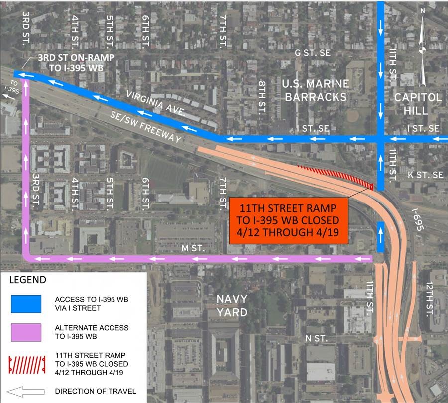 The newish, somewhat hidden ramp from 11th Street to the westbound Southeast Freeway is going to be closed from Saturday, April 12, through Saturday, April 19, "to allow construction crews to continue the demolition of the existing inbound bridge," according to DDOT.
 DDOT has just put out word that the "new" on ramp to outbound I-695 (i.e., the Southeast Freeway to the 11th Street Bridge) will be opening "on or about" tomorrow, April 8.
 * RANDOM PHOTO 2: It seems hard to believe that construction of the long-delayed Capper Community Center could actually be about to start, but this sign erected at 5th and L last week would appear to be another step in that direction.
* TASTE OF 8TH: It's a little outside the JDLand lines, but since hunger knows no boundaries, I'll mention that Taste of 8th is back, on Saturday, May 3, from 1 to 4 pm. For $5 for a single taste or $20 for a five-pack, you can get an appetizer-sized "taste" from many of the restaurants along Barracks Row.
* TINKERING: In my quest to never leave well enough alone, I'm doing some work on the site that may cause things to look (unintentionally) odd. Hopefully if that happens, I'll notice relatively quickly, but I'd be happy if you'd let me know. And, if you're brave, feel free to test out a beta version of the home page that resizes various elements based on your screen width. (Rejoice, ultra-big-screen users!) Just remember that "beta" means I may break it while working on it.
Comments (1)
New 11th Street Ramp to WB Freeway Closing for One Week
Apr 10, 2014 11:26 AM
 The newish, somewhat hidden ramp from 11th Street to the westbound Southeast Freeway is going to be closed from Saturday, April 12, through Saturday, April 19, "to allow construction crews to continue the demolition of the existing inbound bridge," according to DDOT.
 Drivers will be detoured to the long trek down I Street/Virginia Avenue to the ramp at 3rd Street, SE, as the latest arrow-filed map from DDOT shows. (So be careful at the 3rd and Virginia intersection, which might get a bit hairy.)
Comments (0)
More posts:
11th Street Bridges, Traffic Issues
8th Street SE On-Ramp to Outbound Freeway Opening April 8
Apr 7, 2014 3:28 PM
 DDOT has just put out word that the "new" on ramp to outbound I-695 (i.e., the Southeast Freeway to the 11th Street Bridge) will be opening "on or about" tomorrow, April 8.
 "The opening of the new ramp provides a direct connection from Capitol Hill and the Navy Yard/Barracks Row area to northbound DC 295 and southbound I-295 via 8th Street SE."
This ramp, while technically new, is really just the replacement of the old ramp at 8th and Virginia, albeit now shifted a few yards to the north on 8th. My photo above, from a few weeks ago, shows the new ramp, with the outbound freeway lanes to the left, and at right, the under-construction ramp that will bring traffic from the freeway down to the new signalized interchange at 11th Street.
DDOT has also provided a spiffy map for the new ramp, showing all sorts of arrows.
Comments (12)
More posts:
11th Street Bridges, Traffic Issues
Weekend Closures of 11th St. SE and Westbound On-Ramp
Mar 20, 2014 9:40 AM
From DDOT: 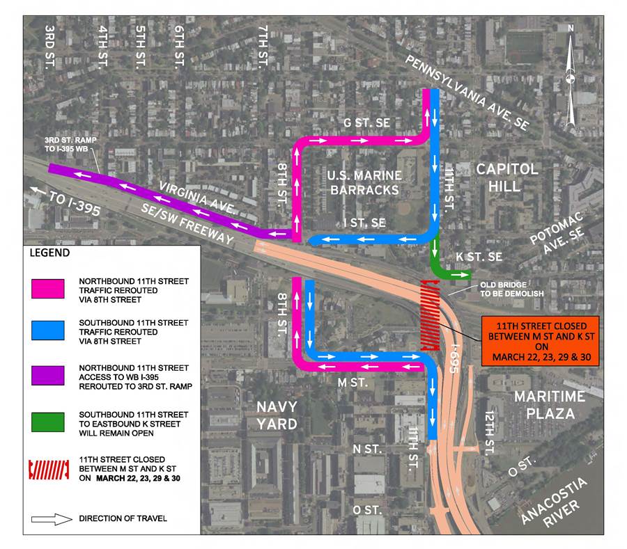 "As part of the 11th Street Bridge Project, the District Department of Transportation (DDOT) will close 11th Street SE, between M Street and K Street, from 7 a.m. on Saturday, March 22, to 11 p.m. on Sunday, March 23, 2014. This closure will also take effect the following weekend, from 7 a.m. on Saturday, March 29, to 11 p.m. on Sunday, March 30, 2014. The 11th Street SE access ramp to westbound I-695 (Southeast/Southwest Freeway) will also be closed during these two closures. The work will allow crews to begin demolition of the existing inbound bridge structure over 11th Street. " See the map for details.
 "As part of the 11th Street Bridge Project, the District Department of Transportation (DDOT) will close 11th Street SE, between M Street and K Street, from 7 a.m. on Saturday, March 22, to 11 p.m. on Sunday, March 23, 2014. This closure will also take effect the following weekend, from 7 a.m. on Saturday, March 29, to 11 p.m. on Sunday, March 30, 2014. The 11th Street SE access ramp to westbound I-695 (Southeast/Southwest Freeway) will also be closed during these two closures. The work will allow crews to begin demolition of the existing inbound bridge structure over 11th Street. " See the map for details.
Comments (0)
More posts:
11th Street Bridges, Traffic Issues
Tuesday Tidbits: Preposition Edition
Mar 18, 2014 5:27 PM
This week's offerings are definitely quite tidbitty: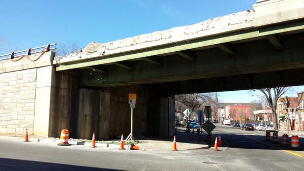 * KNOCKING DOWN: No time has been wasted in starting the demolition of the old inbound flyover from the 11th Street Bridge, as seen in the photo at right.
* KNOCKING DOWN: No time has been wasted in starting the demolition of the old inbound flyover from the 11th Street Bridge, as seen in the photo at right.* FILLING UP: WBJ looks at the ever-widening selection of local beers at Nats Park.
* MOVING IN: There's been a change in the kitchen at Agua 301, with chef Will Vivas (formerly of Recess Tapas Lounge) taking over from original executive chef Antonio Burrell. A press release says that "mainstay" items will remain (like the pork belly tacos), but that "Vivas is developing new selections based on his South American background and training."
* TOPPING OUT: Nats owner Mark Lerner says he doesn't believe the roof the team proposed for the ballpark is going to happen. (WaPo)
* COMING BACK: In case you were concerned, the Bullpen bar at the Fairgrounds at Half and M is returning for another season, beginning on Opening Day (April 4). And yes, this includes Truckeroo, too.
* CROSSING OVER: Greater Greater Washington looks at the possibilities and pitfalls of the proposed 11th Street Bridge Park. The design contest for the park is scheduled to kick off on Thursday. And the project has a spiffy new web site, too.
* CHECKING OFF: Early voting for DC primary elections has begun at One Judiciary Square, with it expanding on Saturday, March 22, to 13 additional sites across the city, including nearby King Greenleaf Recreational Center. April 1 is just around the corner!
Comments (6)
More posts:
11th Street Bridges, agua301, bridgepark, Fairgrounds/Bullpen, Restaurants/Nightlife, politics, Nationals Park
Catching Up on Progress: Roads and Bridges Edition
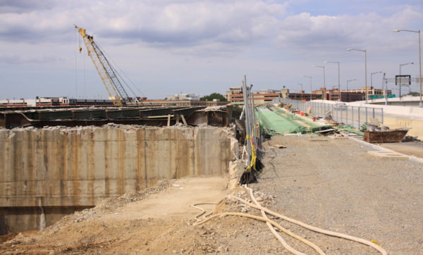
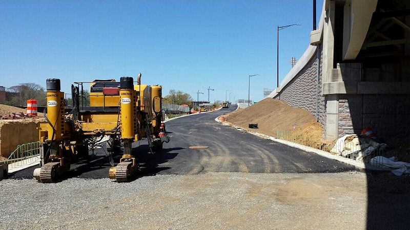
Mar 10, 2014 11:43 AM
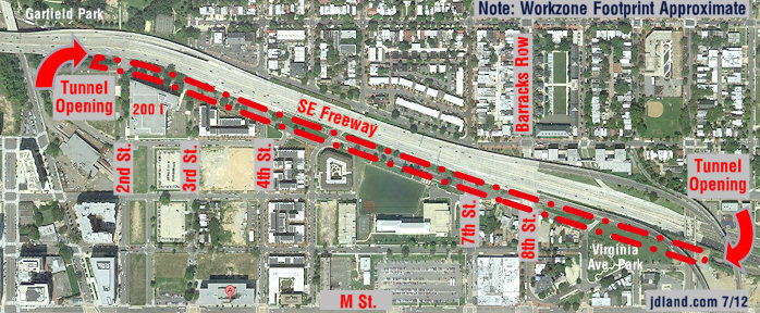
On Sunday I ventured out for a long overdue survey of the 11th Street Bridges project. While I know that pictures of ramps and flyovers don't elicit quite the swooning that images of new residential buildings do, the changes at street level and above since this project began in 2009 are as wide-ranging as anything else in the area short of probably Nationals Park. Here's what I saw (click on photos to embiggen):
On 8th Street just north of Virginia Avenue, the new ramp to outbound I-695 (aka the 11th Street freeway bridge) looks pretty far along, as seen at right. This ramp has an "early spring" projected opening, and it doesn't appear to be too in danger of missing that. 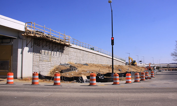
 I also finally checked out 12th Street, which no longer lives quite so deeply in the shadow of the ramp from the old inbound 11th Street Bridge to M Street. The in-water piers of the old bridge are still standing, as you see at left, but otherwise the ramp's footprint has been cleared. (I kind of miss the staircase, though.)

The lanes to the left of this new freeway entrance carry the outbound I-695 traffic, while the ramp to the right that used to lead to the old outbound flyover and bridge will now be the new exit from the freeway to an intersection at 11th Street SE north of L. You can also see this new exit ramp from 8th and Virginia (below left), running next the footprint of the now-demolished old entrance ramp. The 11th Street interchange still has a ways to go (below right), but is projected to open in early summer.


 I also finally checked out 12th Street, which no longer lives quite so deeply in the shadow of the ramp from the old inbound 11th Street Bridge to M Street. The in-water piers of the old bridge are still standing, as you see at left, but otherwise the ramp's footprint has been cleared. (I kind of miss the staircase, though.)
The 12th and O intersection still needs a lot of love even with the embankment gone, but it's at least somewhat less apocalyptic now (below left)--and it will be seeing more traffic with M Street east of 13th temporarily closed, which has also moved the Anacostia Riverwalk Trail route onto its "real" Water Street path. Meanwhile, one block to the north, there's about to be an actual intersection with N Street (below right), allowing for traffic to access 11th Street in either direction without having to go up to M. (You can see the rest of the new 12th and N angles and how they've changed, too.)


So many of the new 11th Street Bridges movements are finished--the bridges themselves, the new inbound and outbound flyovers, the two-way traffic up 11th Street from the local bridge, and the on- and off-ramps at M Street. This also means that the centipede-like old inbound flyover seen in the two photos below can now be demolished like three others before it (the RFK ramps and the outbound flyover), for one final change to the skyline above 11th Street.


It's pretty hard to pull together these changes into a single page, so if you really want to get a feeling for the progression over the past four-plus years, I'd dive into these parts of my photo archive:
* 12th and M, especially looking north and northwest;
* 9th and Virginia, looking northeast and northwest;
* 11th and M, looking northeast, east and southeast;
* 11th and the freeway, looking northeast;
* 11th and L, looking north, south-southeast, and north-northwest;
* 11th and N, looking north and south; and
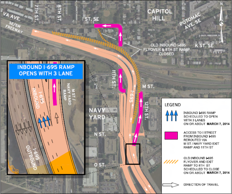 DDOT has announced that on (or about) March 7, inbound traffic on I-695 to the Southeast Freeway will shift over to its final alignment, onto the new flyover built as part of the 11th Street Bridges project.
* 11th and O, looking pretty much in any direction you choose.
I know, it's exhausting. But for someone enamored of striking before-and-after shots, it's a goldmine.
Comments (11)
Inbound I-695 Moving to Final Alignment, Adding Third Lane
Mar 5, 2014 11:52 AM
 DDOT has announced that on (or about) March 7, inbound traffic on I-695 to the Southeast Freeway will shift over to its final alignment, onto the new flyover built as part of the 11th Street Bridges project.
 This shift will also provide a third lane of inbound traffic, and clear the way for demolition of the old, now-somewhat-rickety-feeling, inbound flyover. (Yay!)
In order to complete the final prep for this switchover, the exit ramp from I-695 to M Street will be closed on Thursday, March 6, at 10 pm, until approximately 5 am Friday. If you need to get to M Street from 295, you can get off at the 11th Street local exits and proceed to M that way. This alignment switch is the second in a series of traffic changes related to the 11th Street Bridges project on tap for the early part of 2014. Next in line should be the revamped ramp from 8th Street SE onto the eastbound freeway, sometime this spring, followed in the summer by the new ramp from the eastbound freeway down to 11th Street north of L.
 This alignment switch is the second in a series of traffic changes related to the 11th Street Bridges project on tap for the early part of 2014. Next in line should be the revamped ramp from 8th Street SE onto the eastbound freeway, sometime this spring, followed in the summer by the new ramp from the eastbound freeway down to 11th Street north of L.
However, as is so often the case, progess comes with a price: "Motorists seeking access to 8th Street SE and the Marine Barracks area from the inbound 11th Street Freeway Bridge (westbound I-695) will be detoured to M Street SE, then to 11th Street SE to I Street SE." See the map above for this detour route.
On the graphic released a few weeks ago about the 2014 openings (above right), there appears to eventually be a return of access from westbound I-695 to I Street SE, but is not part of the announced schedule. (It also appears to use the closed-for-security-reasons ramp that bisects the Marine Barracks on I Street, and I'm wondering about the machinations to reopen that.) There will eventually be other movements to and from 11th Street as part of the still-under-discussion Southeast Blvd.
Comments (4)
More posts:
11th Street Bridges, Traffic Issues
New Eastbound Flyover to 11th Street Bridge Opening
Feb 7, 2014 2:59 PM
DDOT is announcing that the new eastbound/outbound flyover from the Southeast Freeway to the 11th Street Bridge (I-695) is opening Feb. 7, i.e., today, i.e., Any Minute Now. Maybe it's already open!
If anyone would like to weigh in with further details, please do.
I've had some e-mails of late from readers eyeing the progress on the new outbound flyover from the eastbound Southeast Freeway toward the 11th Street freeway bridge (aka I-695). The flyover appears to be pretty close to opening, but as of now there's no official date-in-stone from the project folks.
UPDATE: It sounds like it is indeed already open. I will have to schedule a joy ride this weekend.
Comments (9)
More posts:
11th Street Bridges, Traffic Issues
11th Street Bridges New Ramp Opening Date Estimates
Jan 15, 2014 11:53 AM
I've had some e-mails of late from readers eyeing the progress on the new outbound flyover from the eastbound Southeast Freeway toward the 11th Street freeway bridge (aka I-695). The flyover appears to be pretty close to opening, but as of now there's no official date-in-stone from the project folks. However, they were nice enough to pass along this graphic showing the estimated dates that four of the ramps now under construction will open. And, because I know some of you just can't bring yourselves to click, I'll summarize:
* The new eastbound/outbound flyover from the freeway is expected to open sometime in the next six weeks or so.
* A third lane westbound/inbound is scheduled to open in the March/April timeframe.
* The new/replacement ramp from 8th Street onto the eastbound/outbound freeway has an "early spring" anticipated opening date.
* The ramp that will offer a new exit from the eastbound freeway directly onto to 11th Street just north of L is expected to open this summer.
And, while I invite you to check out my 11th Street Bridges project page for the background on this on-going project, I admit that I haven't been over there to take pictures since, ahem, October (it's cold! I'm busy! I'm tired! I'm lazy!). But now I will probably be guilted into it.
Comments (4)
More posts:
11th Street Bridges, Traffic Issues
Tidbits: Ice Rink Opening Soon, and Other Goings-On
Dec 5, 2013 8:29 PM
While I keep trying to get myself reacquainted with blogging (a process that clearly is not proceeding smoothly), I'm going to cheat and go with some Tidbits lists every so often, so that at least I can feel like I'm getting the spigot working better, even if it's still sputtering. Also, I have to get used to all these events, specials, and activities, which didn't used to be part of the Near Southeast blogging landscape.
 * The BID reports in its latest newsletter that the Canal Park ice rink is scheduled to open on Monday, Dec. 16. And speaking of the park, if you haven't wandered by, you may not know that Christmas trees and wreaths are for sale there this year. See the market web site for details.
* The BID reports in its latest newsletter that the Canal Park ice rink is scheduled to open on Monday, Dec. 16. And speaking of the park, if you haven't wandered by, you may not know that Christmas trees and wreaths are for sale there this year. See the market web site for details.* On Saturday (Dec. 7), the 11th Street Bridge Park project is holding two "community design meetings" that will provide an update about the project and break out attendees into smaller groups to work on ideas. A nationwide design competition for the project is expected to be launched early in 2014. The bridge park itself is expected to cost $35 million, which at this point is mostly unfunded. One meeting is at 200 I Street SE from 2 pm to 6 pm (details and RSVP here) but there is also a morning meeting. (via DCist)
* ArtYards has the Chalk a Lot street art event on Saturday and Sunday (Dec. 7-8) at the NGA parking lot, 1st and M SE. And see also this Going Out Guide look at the ArtYards project.
* Osteria Morini is now open for lunch, and here's the menu. Plus there's Happy Hour specials now, too, from 4 to 7 pm Monday through Friday. And Post food critic Tom Sietsema took a First Bite there earlier this week.
* Bluejacket is going big with its first New Year's Eve celebration. For your $160 ticket, you'll get an open bar for all Bluejacket brews, plus a DJ and "passed bites." Then there will be a champagne toast as part of the ceremonial midnight keg drop. (No, seriously.) And Bluejacket/Arsenal is now open for lunch, too, and is serving Sunday brunch from 11 to 3, but you probably already know these things.
* VIDA Fitness, coming to the Twelve12 building at the Yards in 2014, is now offering membership pre-sales. Their site says that the Penthouse Pool Club will open on July 1, 2014 and the VIDA Fitness itself on Aug. 25, 2014.
* If you want to look a little farther into the future: WMATA has scoped out the subway alignments it would like to pursue as part of its 2040 "core configuration" plan. How would you feel about a new Blue and Yellow line under 2nd Street from Union Station, turning west with a station at New Jersey and I before heading to Virginia? (It would also run under M Street NW from Georgetown to New York Avenue.) I can't wait to set out from my retirement home with my brain-embedded camera to take photos of this project.
Comments (4)
More posts:
11th Street Bridges, Bluejacket, bridgepark, Canal Park, Events, Metro/WMATA, osteriamorini, The Yards, Parcel A/Yards, Twelve12/Teeter/Yards
Checking Out the Changes Along on 11th Street
Oct 24, 2013 3:18 PM
I was otherwise occupied on Sept. 7, the day of the big celebration on the now-completed 11th Street Local Bridge, but I finally wandered down to that neck of the woods a few days ago with my camera to capture the current state of affairs. And one might say that the landscape at 11th and O has changed a bit thanks to this project:
 The showiest demolition in the neighborhood in years is coming to an end, and while I haven't been able to document it in the obsessive-compulsive way I would have liked, I did manage to make it to 11th Street this weekend to see the gator tail-like final remnants of the old flyover to the outbound 11th Street Bridges before it completely comes down.
But there's more than just the newly wide open spaces at 11th and O. The girders for the new flyover that will carry traffic from the Southeast Freeway to the outbound I-695 bridge are all now in place; couple that with the demolition earlier this year of the old outbound flyover, and you have a very different vista at 11th and L than what's been there up to now:
(The low height of the flyovers above 11th does make that little stretch a bit claustrophobic, though, especially on foot.)
You also now have two-way traffic on 11th between O and M, so that vehicles coming across the local bridge from Anacostia can drive straight north on 11th.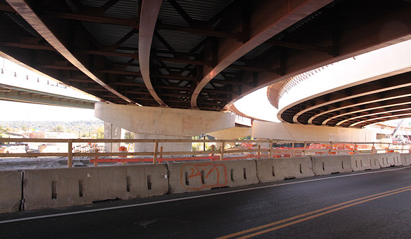


And the dirt-fill-in work for Southeast Blvd. has progressed enough that the west side of 11th at the freeway no longer feels like an overpass, just the regular road.
Plus there's also work at 8th Street and Virginia Avenue to create a new on-ramp and also fashion the new exit to Southeast Blvd./11th Street.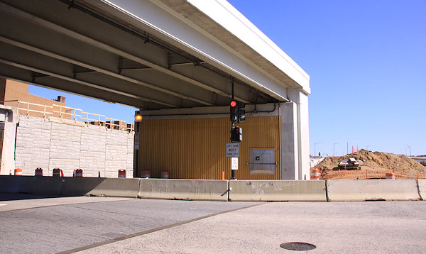


If you don't feel like clicking on each of these photos, just head to my 11th Street Bridges and Southeast Blvd. pages to see them alongside a few other new shots. You may also want to dig into my photo archive to check out the before-and-afters at 11th and the freeway, 11th and L, 11th and M, 11th and N, and 11th and O. Though the photos don't quite seem to do the changes justice, especially if you're someone who has walked those blocks of 11th many times over the past few years.
Comments (0)
Photos: Tearing Down, Filling In, Building Out, Building Up
May 27, 2013 9:54 PM
 The showiest demolition in the neighborhood in years is coming to an end, and while I haven't been able to document it in the obsessive-compulsive way I would have liked, I did manage to make it to 11th Street this weekend to see the gator tail-like final remnants of the old flyover to the outbound 11th Street Bridges before it completely comes down.
At the same time, I was able to check out the progress on the filling-in of the sunken eastern portion of the Southeast Freeway to build Southeast Blvd., and dang if they haven't already piled the dirt up so that 11th Street is now level with the "land" just to its west.
Needless to say, I had to create a photo gallery of the remants and the progress, where you'll also see that work is speeding along on the new flyover to the outbound I-695 bridge.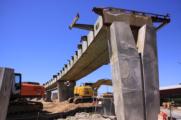


But I wasn't just interested in the tearing down and filling in, so I continued down to O Street, where not only is the 11th Street Local Bridge inching ever closer to getting all of its lanes and pedestrian path opened, but the new asphalt Anacostia Riverwalk Trail path to the river has been laid, which also takes you to the spiffy new landing just completed by the riverside. And from that landing you can see the spiffy new overlooks that reach out onto the old bridge piers from the new local bridge. (For the record, I could have easily sidestepped the construction barrels and ventured onto the overlooks, but I am a good little citizen.)
Lots of images of the new trail, the landing, the bridge, and the surroundings are in a second new photo gallery.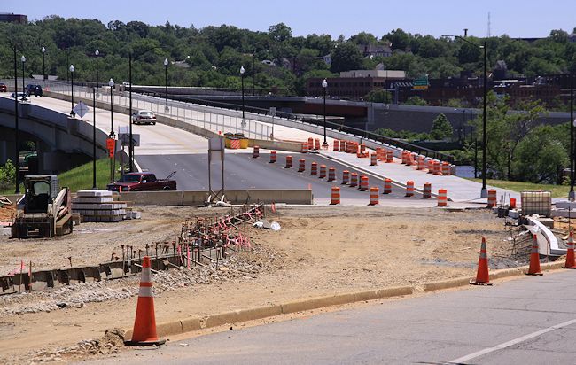
 If these two galleries aren't enough, you might take some time to browse my before-and-afters all the way down 11th Street, from the freeway to L to M to N to O to the river, as nearly four years of construction have altered the vistas from a maze of flyovers and embankments to, well, a completely different maze of flyovers and embankments. (But the new flyovers are a little lower on the horizon, at least.)

 If these two galleries aren't enough, you might take some time to browse my before-and-afters all the way down 11th Street, from the freeway to L to M to N to O to the river, as nearly four years of construction have altered the vistas from a maze of flyovers and embankments to, well, a completely different maze of flyovers and embankments. (But the new flyovers are a little lower on the horizon, at least.)
I also checked out the other projects that are in various stages these days, from Twelve12 to the Lumber Shed to the leafed-out and fountain-ed Canal Park to the hole in the ground that will be the Park Chelsea.
There's new pictures on each of those pages, but I also couldn't help myself and pulled together a third photo gallery, with photos from those spots and a few others that were particularly photogenic on a particularly photogenic day. (It even includes my very first visit to the footprint of one of the neighborhood's most central locations. Where might that be?)


[A postscript: I truly think Sunday was the most perfect day for taking pictures in the 10-plus years I've been wandering the neighborhood, with the achingly clear deep blue sky perfectly matched with the late-May sun strength and positions. I ended up walking more than eight miles in three separate treks, and came home with a smidge more than 1,000 photos, about 300 of which are now in my photo archive.]
Comments (3)
More posts:
11th Street Bridges, Lumber Shed/Yards, photos, riverwalk, Southeast Blvd., The Yards, Parcel A/Yards, Twelve12/Teeter/Yards
Latest 11th Street Bridges Overlook/Trail Renderings
Mar 19, 2013 3:58 PM
The latest presentation slides from last week's 11th Street Bridges project's Community Communications Committee Meeting have been posted, and a few of them caught my eye (or bought my eye, for you fans of obscure Monty Python references). TheWashCycle recently posted a photo of the work underway on the overlooks that are now under construction just down-river of the new local bridge, using the old piers as their bases, and this is what they are expected to look like when completed (click to enlarge):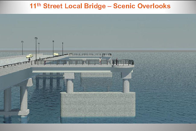

 There is also a rendering (seen at right) of how the Anacostia Riverwalk Trail will run both under the bridges and down from O Street when finished; it also shows the small overlook that will be built out into the river just to the east of the entrance gate to the Navy Yard Promenade. WashCycle also got a recent photo of the path under construction, where you can see the outlines of what the rendering shows is coming.
 As I wrote a few days back, the portion of the Southeast Freeway between 8th Street SE and Pennsylvania Avenue will be fully closed after the evening rush hour on Thursday, Jan. 31, to both begin work on the new Southeast Blvd. and to demolish the existing outbound flyover ramp and replace it with a new three-lane one.

 There is also a rendering (seen at right) of how the Anacostia Riverwalk Trail will run both under the bridges and down from O Street when finished; it also shows the small overlook that will be built out into the river just to the east of the entrance gate to the Navy Yard Promenade. WashCycle also got a recent photo of the path under construction, where you can see the outlines of what the rendering shows is coming.
The presentation slides also have some photos of the demolition underway on the old outbound freeway flyover, and aerial photos of the work that's completed and still underway on the east side of the river. There's also, on page 21, an image which looks like they've already almost completed the filling-in of the portion of the Southeast Freeway between 8th and 11th, since it shows dirt almost up to the underside of the existing bridge that takes 11th Street across the sunken freeway between I and L.
What all of this really means is that I need to get back to 11th Street with my camera pretty soon, since my last batch of photos is now a bit dated (waaah!).
Comments (11)
More posts:
11th Street Bridges, Pedestrian/Cycling Issues, riverwalk
Full Closure of SE Freeway East of 8th Begins Jan. 31; New Southeast Blvd. Page, and 11th Street Bridges Progress Pics
Jan 30, 2013 11:02 PM
 As I wrote a few days back, the portion of the Southeast Freeway between 8th Street SE and Pennsylvania Avenue will be fully closed after the evening rush hour on Thursday, Jan. 31, to both begin work on the new Southeast Blvd. and to demolish the existing outbound flyover ramp and replace it with a new three-lane one.
One thing I didn't mention in that post is that, with these closures Thursday, both the 8th Street SE on-ramp to the outbound I-695 freeway bridge and the 9th Street ramp toward Pennsylvania Avenue will be closed.
As the helpful graphic at right from DDOT shows, if you're wanting to get on I-695 outbound, you'll need to use the ramp on the southeast corner of 11th and M.
Since this closure now makes the Southeast Blvd. project truly seem underway, I've been spurred into an unexpected burst of action, and have created a Southeast Blvd. project page, separate from my recently refreshed 11th Street Bridges page. Right now it's mainly drawings, "before photos," and links to my previous posts on the project, but I will keep it updated throughout the expected 18-to-20-month span of construction: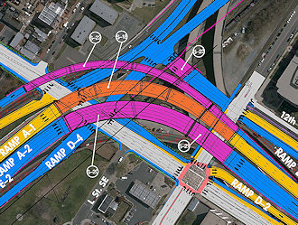
The next step in converting the sunken portion of the Southeast Freeway between 8th Street SE and Pennsylvania Avenue to the eventual at-grade "Southeast Boulevard" is coming, as DDOT has announced that on Jan. 31, "all eastbound lanes along this stretch will be closed to traffic for approximately 18-20 months while crews fill the roadway to restore it to the local street elevation."
I also threw together a new 11th Street Bridges Progress Photo Gallery with some new shots from this past weekend, when I traipsed around N and O streets and up on the local bridge for the first time in way too long.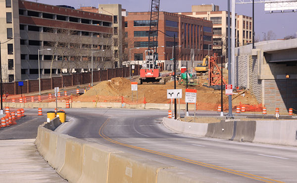
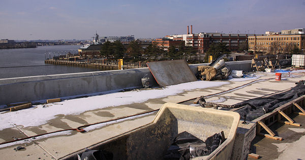

And now I think my guilt over some long-neglected photos is assuaged, at least for a little while.
Comments (9)
Eastbound SE Freeway to Pennsylvania Ave. Closing Jan. 31
Jan 19, 2013 4:03 PM
 The next step in converting the sunken portion of the Southeast Freeway between 8th Street SE and Pennsylvania Avenue to the eventual at-grade "Southeast Boulevard" is coming, as DDOT has announced that on Jan. 31, "all eastbound lanes along this stretch will be closed to traffic for approximately 18-20 months while crews fill the roadway to restore it to the local street elevation."
 This will be preceded by for a week or so beginning around noontime on Tuesday, Jan. 22, with the route being reduced to only one lane.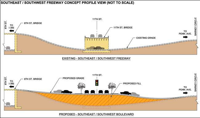 Not only are these closures to allow for the filling-in of much of the old roadway, but also to start construction of bridge piers for "a new bridge over the SE Freeway," which I believe will be the new three-lane flyover ramp from the freeway to the outbound 11th Street Bridge, replacing the current one (seen at top left in the photo).
 Not only are these closures to allow for the filling-in of much of the old roadway, but also to start construction of bridge piers for "a new bridge over the SE Freeway," which I believe will be the new three-lane flyover ramp from the freeway to the outbound 11th Street Bridge, replacing the current one (seen at top left in the photo).
If you're worked up about this closure because you're using the route to Pennsylvania Avenue to then use the left-turn-to-DC295, you should already be using the new exit ramp from the outbound 11th Street Bridge directly to northbound 295 anyway!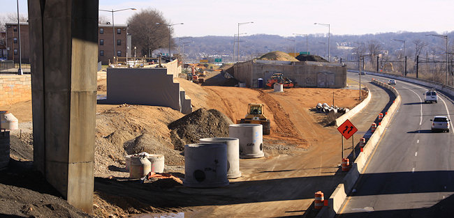 The work of bringing in lots and lots (and lots and lots) of dirt to build up the sunken route has already begun on the old westbound side of the road, as seen in this photo I took earlier this month, when I also updated the before and afters for the 11th Street & not-yet-Southeast-Blvd intersection.
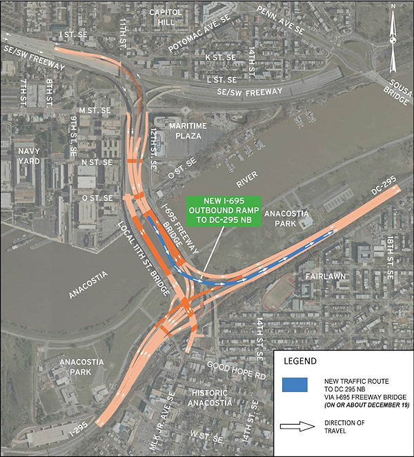 UPDATE, Dec. 19: A tweet from DDOT confirms that the new ramp is "slated to open this afternoon, possibly in time for evening rush hour." UPDATE TO THE UPDATE: According to NBC4's Adam Tuss, the ramp is now open.
 The work of bringing in lots and lots (and lots and lots) of dirt to build up the sunken route has already begun on the old westbound side of the road, as seen in this photo I took earlier this month, when I also updated the before and afters for the 11th Street & not-yet-Southeast-Blvd intersection.
If you haven't been following this project, which is part of the $90 million second phase of the 11th Street Bridges project, the filling-in is so there will be an at-grade signalized intersection at 11th Street, SE. Drivers will arrive at the new intersection from the SE Freeway (or Pennsylvania Avenue) and have the option of getting onto 11th Street, or continuing straight. There will also be a new stretch of 12th Street north of M to Southeast Blvd., so that drivers exiting the 11th Street freeway bridges can continue north across M to the new boulevard, instead of turning left onto M and then right onto 11th.
There is also supposed to be a new pedestrian/cycling trail alongside this new Southeast Blvd., creating another connection between Virginia Avenue Park and Barney Circle than using the currently-ripped-up-by-DC-Water M Street route.
This construction drawing shows all the new intersections, ramps, flyovers, and whatnot for both phases of the project on the west side of the river, if you need some help visualizing.
There are also supposed to be public meetings coming this year as part of studies now underway on how to remake the Barney Circle-not-yet-Southeast-Blvd interchange.
Comments (1)
More posts:
11th Street Bridges, Southeast Blvd., Traffic Issues
DDOT: I-695 Ramp to DC-295 Northbound Opening Today (Updated)
Dec 13, 2012 4:17 PM
 UPDATE, Dec. 19: A tweet from DDOT confirms that the new ramp is "slated to open this afternoon, possibly in time for evening rush hour." UPDATE TO THE UPDATE: According to NBC4's Adam Tuss, the ramp is now open.
Original post: Just out from DDOT, an announcement that the long-awaited ramp from the outbound 11th Street freeway bridges (now known as I-695) to DC-295 northbound is expected to open "on or about December 19." This means that vehicles traveling eastbound on the southeast freeway can now remain on the freeway for their entire trip to DC-295 northbound, instead continuing along the stub of the Southeast Freeway ending at Barney Circle, then traveling across the Sousa Bridge to then endure a nightmare left turn onto DC-295.
Not mentioned in the announcement is whether at the same time the old route to Pennsylvania Avenue will be closed--if it doesn't close the 19th (see Update II below), it will be closing soon, as part of the two-year reconfiguration of that road as "Southeast Boulevard."
{I'm psychic!}
UPDATE: I should also note that, according to the graphic at right, eastbound freeway traffic will start being routed (temporarily!) on the new flyover built during the past few years that will eventually carry inbound traffic; but using it for outbound traffic at this point allows the existing older outbound flyover to be demolished to make way for a new outbound flyover. Photos and additional explanations here and here.
UPDATE II: However, if you're used to getting onto the eastbound freeway and 11th Street Bridges via the ramp at 8th and Virginia, be advised that ramp will close when demolition begins of the old outbound flyover, which is expected to start in late January. And, to answer another lingering question from this post, that's when the eastbound freeway east of 8th will be closed, which also means that the little ramp from 9th and Virginia to the eastbound freeway stub will be closed as well. (This all from @DDOTDC on Twitter.) You'll be able to access the new ramp to DC-295 northbound by getting on eastbound I-695 via the new-ish ramp on the southeast corner of 11th and M; in fact, the entrance lane from that ramp I believe puts you directly in the DC-295 NB exit lane. Or, if you're on the western end of the neighborhood, you can get on the eastbound freeway at South Capitol Street (only in my fever dreams).
Comments (7)
More posts:
11th Street Bridges, Southeast Blvd.
Coming Nov. 29: New 11th Street SE Freeway On-Ramp Opening, Far Westbound Freeway Portion Closing
A release just out from DDOT is announcing that the new ramp from 11th Street SE to the westbound Southeast/Southwest Freeway wll be opening on Thursday, Nov. 29. This means that vehicles from the eastern ends of Capitol Hill and Near Southeast won't have to drive along Virginia Avenue to the 3rd Street SE on-ramp anymore; it will also give easier westbound freeway access to traffic coming inbound on the 11th Street Local Bridge.
The 11th Street Bridges folks were nice enough to pass along a more recent drawing (March 2012, Concept Only! Not for Construction!) that shows the 11th Street Bridges' project Phase 2 plans.
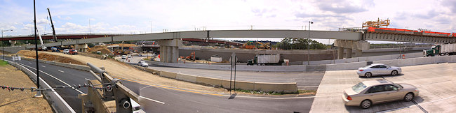
Also on Nov. 29, the westbound portion of the sunken SE Freeway between Pennsylvania Avenue/Barney Circle and 8th Street SE will be fully closed, as work continues on creating the new "Southeast Blvd." Drivers heading south on DC-295 who have long exited onto Pennsylvania to go west on the SE/SW Freeway will be directed to use the inbound 11th Street Freeway Bridge.
I wrote a lot about these changes back in September, so I'll just point you to those three posts for additional information and photos, or you can wander through my 11th Street Bridges project page.
Comments (4)
More posts:
11th Street Bridges, Southeast Blvd.
Zooming in on the 11th Street Bridge's Phase 2 Plans
Sep 27, 2012 9:48 AM
The 11th Street Bridges folks were nice enough to pass along a more recent drawing (March 2012, Concept Only! Not for Construction!) that shows the 11th Street Bridges' project Phase 2 plans. They were also nice enough to pass along a very large version of this more recent drawing, enabling me to post a very large image in on the new ramps and lanes along and over 11th Street on the west side of the Anacostia River, and how the new Southeast Boulevard with a new signalized intersection at 11th Street will be built along what used to be the eastern end of the Southeast Freeway. It also shows the extension of 12th Street north of M to the new boulevard, along with all of the turn lanes and other movements. (All of this assuming the designs don't change.)
It's also handy if you haven't committed all the Phase 1 ramps and flyovers and lanes and paths to memory--they are shown in yellow and orange, while the Phase 2 plans are in blue and pink, and decommissioned roads and ramps are in a subtle x'ed-out motif. So, for the heck of it, here's a not-quite-so-enlarged image showing the entire project, on both sides of the river. Also, if you missed it, my photo gallery of the project's current state, from earlier this month.
(I should note that this map doesn't include how upcoming changes to Barney Circle might look, because that's still under deliberation.)
Comments (4)
More posts:
11th Street Bridges, Southeast Blvd., Traffic Issues
11th Street Bridges Project Photo Tour, September 2012
Sep 19, 2012 8:35 AM
There's a lot going on over yonder at 11th Street these days, as the initial 11th Street Bridges project continues toward its expected completion next year while the now-funded Phase 2 work is starting to get underway.
I was able to arrange a tour last week (thank you, bridge folks!), and have put together a photo gallery of the most interesting shots.
However, there's a lot going on and so I'm going to break out some of the information here as well. (But go look at the gallery too!)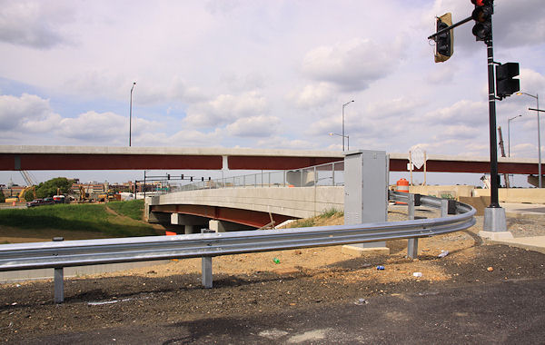 New Ramps from/to 11th Street Local Bridge
 New Ramps from/to 11th Street Local Bridge
By the end of the month (or maybe even by the end of the week), two new ramps on the 11th Street Local Bridge will open, providing access to southbound I-295 from the local bridge and to the local bridge from northbound DC-295. There are signalized intersections at both ramps, with turns allowed in each direction. And, once construction is finished to make 11th Street two-way from O Street northward, commuters driving north on 295 will be able to use the new ramp to the local bridge to then arrive directly at the Navy Yard's entrance gate at 11th and N.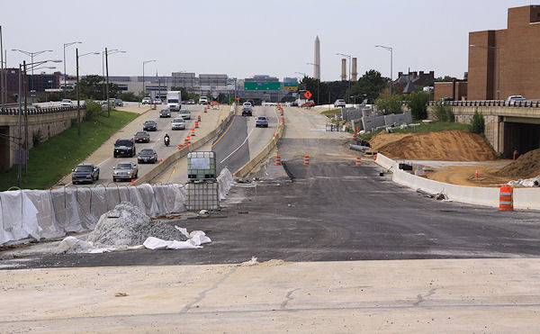 Southeast Blvd., and Outbound Freeway Traffic
 Southeast Blvd., and Outbound Freeway Traffic
This week saw the first of the lane closures that within a few months will signal the end of the SE Freeway east of 8th Street. Once all lanes are closed, traffic taking the old two-lane flyover to outbound I-695 will be temporarily routed onto the completed-but-not-opened inbound flyover connecting I-695 and I-395. This will allow for the razing of the old outbound flyover, and construction of a new three-lane flyover in the gap between the old and new ones. The filling of the old sunken freeway will also begin, for the new at-grade Southeast Blvd.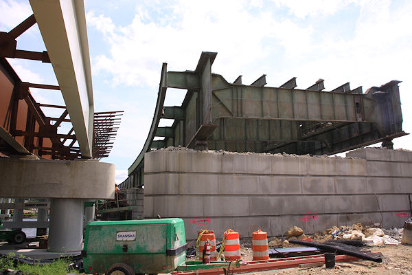 Old Outbound Bridge Demolition
An advisory sent out by DDOT this afternoon (now online) has announced some upcoming changes to the traffic flow on the Southeast Freeway east of 8th Street, SE, as the work begins to get underway for the creation of the new at-grade boulevard that will take traffic to and from the Southeast Freeway and Barney Circle.
 Old Outbound Bridge Demolition
The old outbound 11th Street Bridge is now little more than a bunch of old girders, which are starting to be removed. Soon, all that will be left will be the river piers, though two of those will be used to create viewing platforms that will be accessed via walkways from the new 11th Street Local pedestrian path. (And can be reused if anyone ever decides to pony up the millions needed to create the 11th Street Recreation Bridge.) In the meantime, work continues on the downriver edge of the new local bridge, to get it to its full four-lane-plus-ped-path width.
But there's more than just these items and photos. There's photos of the under-construction ramp that in about three months will take traffic from outbound I-695 to northbound DC-295, plus the big piles of dirt waiting to be used to fill in the eastern part of the Southeast Freeway, and the work on the ramp from 11th Street to westbound I-395, and more. So go look at the entire gallery. (I've also incorporated some of the new photos into my 11th Street Bridges project page, to go with the before-and-afters.) I also wrote in more detail about the Phase 2 projects a few months back.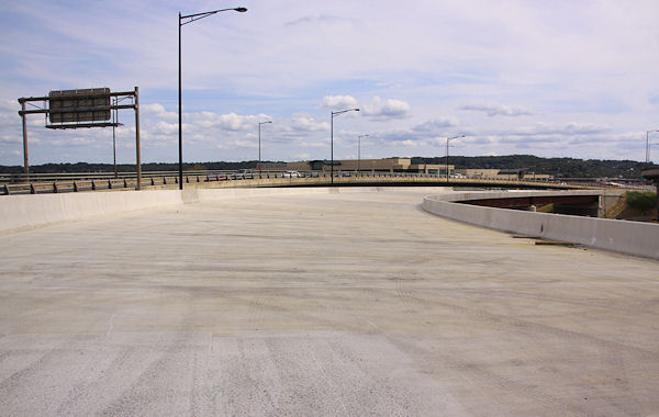


Comments (6)
Work Starting Soon on Eventual Southeast Boulevard
Sep 11, 2012 2:49 PM
An advisory sent out by DDOT this afternoon (now online) has announced some upcoming changes to the traffic flow on the Southeast Freeway east of 8th Street, SE, as the work begins to get underway for the creation of the new at-grade boulevard that will take traffic to and from the Southeast Freeway and Barney Circle.Starting Monday, Sept. 17, after morning rush hour, westbound traffic from Barney Circle to the freeway on the current below-grade lanes will be reduced to a single lane. By November, DDOT says, the westbound lanes will be closed completely, and by January the eastbound lanes will be, too.
DDOT also says that, starting Monday, vehicles will no longer be permitted to turn left from southbound 17th Street SE to reach the restricted access lanes under Barney Circle.
Over an 18- to 20-month period, the below-grade area between 8th and 13th streets SE will be raised about 20 feet, and the new boulevard will be created, as seen in this DDOT graphic. Since 11th Street currently crosses the below-grade lanes on a bridge, this means that that "bridge" will become an at-grade roadway as well.
And, speaking of that section of 11th Street, the advisory says that the new entrance to the westbound Southeast Freeway from 11th Street will open by Thanksgiving, allowing people on the eastern side of the Hill to get on the freeway at 11th rather than taking Virginia Avenue all the way to the 3rd Street SE ramp. This work is all part of the now-funded $90 million second phase of the 11th Street Bridges project, and also will include a new three-lane outbound bridge from the SE/SW Freeway to the 11th Street/I-695 bridge. In addition, 12th Street SE will be extended north from M Street to connect to the new Boulevard, and there will also be a reconfiguring of Barney Circle itself.
 This is a little bit out-of-boundaries, but people who drive into Near Southeast (and Capitol Hill, and Southwest, etc.) may find it of note. Signage first hinted at it earlier this week, and now WTOP reports (and DDOT confirms via e-mail) that on Monday afternoon, July 30, the new ramp will open from southbound DC-295 to inbound I-695, i.e., the 11th Street Bridges' freeway span that feeds into the Southeast/Southwest Freeway. WTOP quotes DDOT deputy chief engineer Ravindra Ganvir as saying, "This piece has been missing for about 50 years. We're very excited about it."
 This work is all part of the now-funded $90 million second phase of the 11th Street Bridges project, and also will include a new three-lane outbound bridge from the SE/SW Freeway to the 11th Street/I-695 bridge. In addition, 12th Street SE will be extended north from M Street to connect to the new Boulevard, and there will also be a reconfiguring of Barney Circle itself.
In the meantime, work continues on the many Phase 1 connections still being built, including a new off-ramp on the east side of the river from northbound DC-295 to the new 11th Street Local Bridge, which should be opening by the end of this month. Quoting DDOT: "This will allow Navy Yard morning rush-hour commuters coming from Suitland Parkway and northbound I-295 with more of a direct route to their facility as well as local traffic direct access to Historic Anacostia. Traffic will exit on the Anacostia side of the river, travel across the 11th Local Street Bridge and enter the Navy Yard at the O Street Gate."
The much-anticipated ramp to northbound DC-295 from the outbound I-695 bridge is expected to open by Thanksgiving.
You can see more about the coming ramps on the east side of the river on page 31 of this DDOT community communications briefing. There's also my post from a few months ago with more detail on this Phase 2, and of course, my 11th Street Bridges project page.
Comments (7)
More posts:
11th Street Bridges, Southeast Blvd., Traffic Issues
New Ramp from DC295 Southbound to I-695 Opens Monday
Jul 27, 2012 4:01 PM
This is a little bit out-of-boundaries, but people who drive into Near Southeast (and Capitol Hill, and Southwest, etc.) may find it of note. Signage first hinted at it earlier this week, and now WTOP reports (and DDOT confirms via e-mail) that on Monday afternoon, July 30, the new ramp will open from southbound DC-295 to inbound I-695, i.e., the 11th Street Bridges' freeway span that feeds into the Southeast/Southwest Freeway. WTOP quotes DDOT deputy chief engineer Ravindra Ganvir as saying, "This piece has been missing for about 50 years. We're very excited about it."WTOP got a sneak preview, and made it from Nannie Helen Burroughs Avenue in Northeast to 6th Street SW in about 10 minutes, while another driver at the same time going the old way, via Pennsylvania Avenue, needed 19 minutes.
Of greater interest might be the next big piece of the reconstruction: the new ramp from the outbound freeway bridge to go northbound on DC-295, negating the need for either the ghastly left turn on Pennsylvania Avenue or wandering through Capitol Hill to get on DC-295 at RFK.
UPDATE: The second I posted this entry, I got an e-mail from DDOT with this announcement of the public event opening the span at 10:30 Monday morning, and this flyer explaining the new traffic movements.
UPDATE II: Here's the post about the opening on the Anacostia Waterfront Initiative web site, in case you don't believe me.
UPDATE, 7/30: Aaaand, it's open.
Comments (9)
More posts:
11th Street Bridges
11th Street Bridge Demolition Photos, Phase 2 Green Light
Jun 26, 2012 9:37 AM
The intersection of 11th and O has changed a bit over the past few weeks: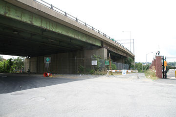
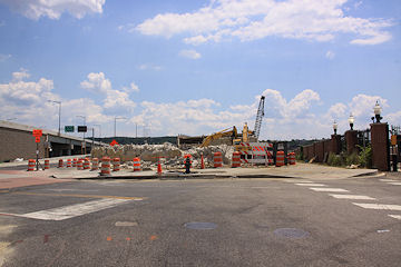
On the left is the old 11th and O looking south-southeast, while the picture on the right shows the new view, with the overpass for the old outbound 11th Street Bridge now a pile of rubble, and the new bridges at left and center, far more visible in person than in this low-res photo, of course. (At right is the path down to the Riverwalk, with the Navy Yard fence at far right.)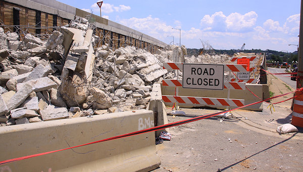 Speaking of rubble, there's no shortage of it at 11th and N (at right), where the on-ramp to the old outbound bridge is getting torn down.
 Speaking of rubble, there's no shortage of it at 11th and N (at right), where the on-ramp to the old outbound bridge is getting torn down.
These and a number of other new photos from Sunday are now posted on my 11th Street Bridges page. The full photo archives for 11th at M, N, and O may also be of interest to construction and demolition geeks, to see exactly how much this stretch of road has changed over the past few months. (Users of the Riverwalk who haven't ventured to this spot in a few weeks might also like checking it all out.) While I finally made my first trip across the new local bridge by bike on Monday, I haven't gotten up there with a camera yet, but hope too, soon.
(If you like these sorts of disappearing-overpass images, be sure to step into the time machine to see my photos from the demolition of the South Capitol Street viaduct five years ago.)
The rest of the 11th Street bridges project continues to move forward, with the next big milestone being the opening of a new ramp on the east side of the river from southbound DC-295 to the inbound 11th Street Freeway/I-695 bridge. (Page 16 of this June 11 presentation packet says "on or about June 27" for that opening, so maybe this is going to happen really soon, though as of now there's been no announcement.) Then, sometime in the fall, the next big "missing movement" will open, which is the ramp from the outbound freeway/I-695 bridge to northbound DC-295. Following that will be ramps to and from DC-295 and the local bridge. Also in there at some point should be the new ramp from 11th Street to go westbound on the freeway, replacing the long trek down Virginia Avenue to 3rd Street for many people.And, the wheels have started to turn on the project's second phase, with a $90 million contract awarded to Skanska/Facchina. Page 17 of the presentation packet (seen at right and here) shows in red and blue the additional ramps and movements that will be built by late 2015, including:
And, the wheels have started to turn on the project's second phase, with a $90 million contract awarded to Skanska/Facchina. Page 17 of the presentation packet (seen at right and here) shows in red and blue the additional ramps and movements that will be built by late 2015, including:* The new "Southeast Boulevard" that will replace the sunken part of the Southeast freeway between 11th Street and Pennsylvania Avenue, with signalized intersections at 11th Street;
* A new extension of 12th Street north of M to allow traffic exiting I-695 to continue north to the new Southeast Boulevard and then turn right to go to Pennsylvania Avenue/Barney Circle or left to 11th Street;
* A new flyover ramp from the eastbound Southeast Freeway to outbound I-695, adding an additional lane of volume and presumably being built at the same level as the new inbound flyover, which will allow the taller old outbound flyover to be demolished;
* Additional lanes on northbound 11th between M and the new Southeast Boulevard interchange;
* And probably a few other items that are hard to discern in the drawing.
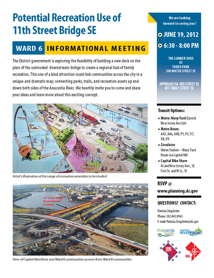 The Office of Planning isn't exactly lighting up the Intertubes promoting this, but apparently there's another "informational meeting" on the notion of turning the old outbound 11th Street Bridge into a "recreational bridge" tonight at 6:30 pm at the Lumber Shed in the Yards Park.
As I posted a few weeks ago, the new Anacostia Waterfront web site mentions that an environmental review will be coming this fall of a combined Barney Circle/Southeast Boulevard Project that will "reconstruct Barney Circle from a misnomer into a true traffic circle, while transforming the easternmost dead-end section of the Southeast/Southwest Freeway into a boulevard between the circle and 11th Street, SE." It also describes the Southeast Boulevard reconstruction as "converting the roadway from a below-grade freeway into a four-lane at-grade boulevard with a green median and adjacent new multi-use trail to allow bicycle and pedestrian travel not currently possible in this area."
(You know what would be keen? If the improvements to Virginia Avenue that CSX is looking at post-tunnel construction would include bike lanes all the way to Virginia Avenue Park, which could then maybe hook up with some sort of bike path across the north side of the park to 11th Street, where it would then access the Southeast Boulevard trail. Then there'd be a complete bike route from Barney Circle and points north on the Anacostia Riverwalk Trail all the way to Southwest, via a one-block jog from Virginia over to I Street SE at 2nd or 3rd or 4th, since I Street will be built between 2nd and New Jersey within a few years. This also might alleviate the issues with the Navy Yard and Yards portions of the Riverwalk not really being open to bikes.)
For more information on all of this, see my project page, the AWI 11th Street Bridges section, and the latest "Eleventh Street Ledger" newsletter.
Comments (6)
More posts:
11th Street Bridges, photos, Southeast Blvd.
11th Street Recreation Bridges Meeting Tonight
Jun 19, 2012 10:13 AM
 The Office of Planning isn't exactly lighting up the Intertubes promoting this, but apparently there's another "informational meeting" on the notion of turning the old outbound 11th Street Bridge into a "recreational bridge" tonight at 6:30 pm at the Lumber Shed in the Yards Park.
According to an e-mail forwarded around by ANC commissioner David Garber (I haven't seen mention of the event anywhere else), the meeting's primary purpose is to get ideas about the kinds of attractions and features that OP would then want to put into the design competition they plan to hold for the bridge. There's no funding for any actual construction at this point, and a private partner would probably have to be found to foot the not-miniscule tab to build a new decking across the river on the footings that will remain now that the current deck is being demolished.
Tuesday Tidbits: Bridge and Tunnel (and River) Edition
Jun 5, 2012 4:26 PM
* The Post writes about Virginia Avenue residents battling CSX on tunnel plans. (The comments section is festive as well.)
* The Navy Yard alerts folks that the 11th & O gate to their part of the Riverwalk will be closed for approximately three weeks because of demolition work on the old outbound 11th Street Bridge. (This means that the Navy Yard Riverwalk itself isn't closed, it just means you can only access it west of 11th Street.)
* Speaking of the old bridge, City Paper writes that this demolition doesn't mean the end of the "recreation bridge across the Anacostia" idea, just that it was determined that it would be better to take off the old bridge deck than to try to maintain it while working on the recreation bridge idea, which will still need financial backing even after the design competition is held this fall.
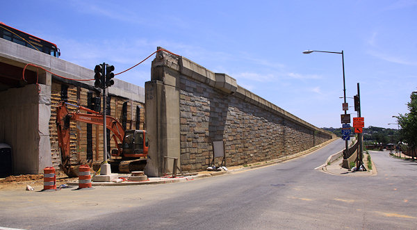 Late Friday, DDOT sent out word that there will be overnight closures of 11th Street south of M this coming week to "perform demolition activities on the old outbound 11th Street Bridge." What I imagine this is referring to is the old ramp from N Street to the outbound bridge, which needs to be removed in order to allow traffic to flow on the new 11th Street alignment to and from the 11th Street Local Bridge that opened Thursday.
 I managed to drag myself over to 11th Street on Saturday with camera in hand to check out the new ramp that opened on Friday from M Street up to the outbound freeway bridge (which I guess we'd all better start getting used to calling I-695 East). And of course I also then had to wander down to N Street, and then to O Street, to see the progress of the work on the 11th Street Local bridge, which apparently will also be opening soon (see update below), though I've heard it will be just a "partial" opening at first.
* Speaking of the river, DDOT has launched AnacostiaWaterfront.org as a new online home for information on projects along the river, such as the 11th Street Bridges, the planned new South Capitol Street Bridge and associated corridor upgrades, the Riverwalk, and other projects.
* One tidbit unearthed in the new web site: An environmental assessment is expected to start this fall on reconstructing Barney Circle and transforming the "easternmost dead-end section of the Southeast/Southwest Freeway into a boulevard between the circle and 11th Street, SE."
Comments (0)
More posts:
11th Street Bridges, West Half St., Anacostia Waterfront Initiative, bridgepark, CSX/Virginia Ave. Tunnel, riverwalk
11th Street Overnight Closures This Week for Old Ramp Demolition
May 28, 2012 10:48 AM
 Late Friday, DDOT sent out word that there will be overnight closures of 11th Street south of M this coming week to "perform demolition activities on the old outbound 11th Street Bridge." What I imagine this is referring to is the old ramp from N Street to the outbound bridge, which needs to be removed in order to allow traffic to flow on the new 11th Street alignment to and from the 11th Street Local Bridge that opened Thursday.
On May 29, 30, and 31, DDOT will close 11th Street SE from M to O starting at 7 pm through 5 am the following morning. Traffic heading for Anacostia from 11th Street will be detoured onto the new I-695 East ramp at 11th and M, then to Howard Road SE to access Martin Luther King Jr. Ave. (It's left unsaid in the advisory, but it sounds like traffic inbound from Anacostia on the local bridge will still be allowed, since it uses 12th Street to get to M.)
I haven't made it across the new bridge yet, but WashCycle investigated the temporary pedestrian/bicycle lane, and took some photos. There's also my week-old photos of all of the doings along 11th Street, that included a few peeks at the not-yet-opened-at-that-time bridge.
Comments (4)
More posts:
11th Street Bridges
11th St. Construction Photos: New Ramp, Almost Open Local Bridge
May 20, 2012 11:33 AM
I managed to drag myself over to 11th Street on Saturday with camera in hand to check out the new ramp that opened on Friday from M Street up to the outbound freeway bridge (which I guess we'd all better start getting used to calling I-695 East). And of course I also then had to wander down to N Street, and then to O Street, to see the progress of the work on the 11th Street Local bridge, which apparently will also be opening soon (see update below), though I've heard it will be just a "partial" opening at first.Here's a gallery of 11th Street photos, including explanations of what's going on. The pictures also show the work underway to get the final demolition and clearing done so that 11th Street can become two-way all the way down to the new local bridge. (Though this can't happen completely until the ramp at N Street to the old outbound bridge is demolished, which is why I imagine the new bridge is only "partially" opening, enough to route outbound traffic onto it so that the final demolition can be completed.)
I also added images to my main 11th Street Bridges photo page, but you may also be interested in the more complete before-and-after sets of 11th and M, 11th and N, and 11th and O.
But there's also this view from O Street east of 11th, looking southward, which, in comparing November 2005 to now, shows one heck of a change:
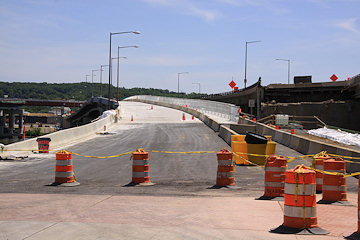
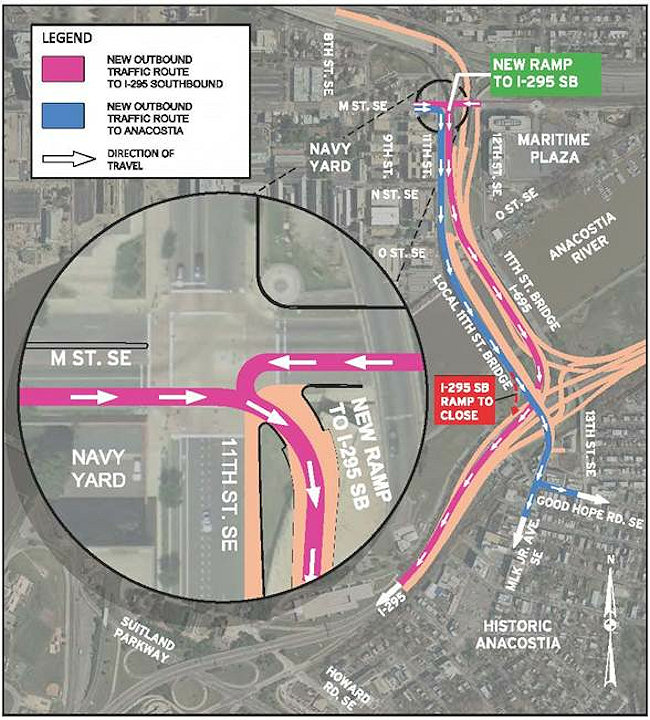 From DDOT, news of another milestone in the 11th Street Bridges reconstruction project:
 DDOT is announcing that the the 8th Street exit ramp from the westbound Southeast/Southwest freeway is closing permanently on May 10 at approximately 10 am.
Once the local bridge is open, the next big milestone will be the completion of the ramps from I-695 eastbound to DC-295 northbound, and from DC-295 southbound inbound across the freeway bridge, both of which are traffic movements that did not exist before this project. (No more dealing with the left turn on Pennsylvania Avenue, or taking New York Avenue outbound, to get to DC-295 from Near Southeast, Capitol Hill, and the Southeast Freeway.)
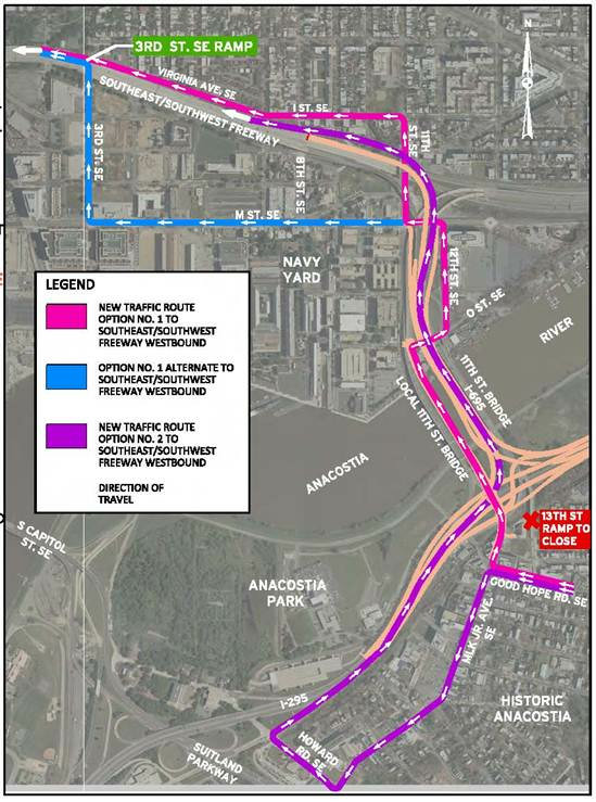 UPDATE, 5/21: DDOT has just sent out a release saying that the 11th Street Local Bridge will open "on or about Thursday, May 24." It is indeed a partial opening: "There will be 2 lanes for inbound traffic and 1 lane for outbound traffic towards Anacostia. There will also be a temporary 6-foot separated walkway for pedestrians and cyclists. (The local bridge is scheduled to be completed this fall with 4 travel lanes and a permanent shared pedestrian/bicycle path)." The release also says that the new ramp from southbound DC-295 to the inbound freeway bridge will open in about six weeks, and that the new ramp from 11th Street to the westbound SE Freeway will open by July 4. Click the two images for maps of the temporary routes and patterns.

 UPDATE, 5/21: DDOT has just sent out a release saying that the 11th Street Local Bridge will open "on or about Thursday, May 24." It is indeed a partial opening: "There will be 2 lanes for inbound traffic and 1 lane for outbound traffic towards Anacostia. There will also be a temporary 6-foot separated walkway for pedestrians and cyclists. (The local bridge is scheduled to be completed this fall with 4 travel lanes and a permanent shared pedestrian/bicycle path)." The release also says that the new ramp from southbound DC-295 to the inbound freeway bridge will open in about six weeks, and that the new ramp from 11th Street to the westbound SE Freeway will open by July 4. Click the two images for maps of the temporary routes and patterns.
Note that inbound traffic from the new bridge will be routed up 12th Street SE and then through the 11th and M intersection. The designs for the new bridge have always shown 11th Street becoming two-way, and the work up to M Street would seem to indicate that's still the plan, but the release doesn't say anything about the 12th Street routing being "temporary." Guess we'll have to see.
UPDATE TO THE UPDATE: Nah, as I've been saying all along (such as in Saturday's photo gallery), the 12th Street routing for inbound local bridge traffic is just temporary.
Ramp from M Street to Outbound 11th Street Freeway Opens Friday
May 17, 2012 2:23 PM
 From DDOT, news of another milestone in the 11th Street Bridges reconstruction project:
"The District Department of Transportation (DDOT) will open the newly constructed ramp at the intersection of 11th Street and M Street, SE to traffic on or about Friday, May 18. The new ramp will provide access from the M Street/Navy Yard area to the new outbound 11th Street Freeway Bridge and southbound I-295.
"Access to Historic Anacostia will remain on the old outbound 11th Street Bridge, until the new local bridge opens in the coming days. Existing inbound traffic movements from northbound I-295 to the M Street/ Navy Yard area will also remain the same."
So, don't drive down 11th Street south of M anymore if you're wanting to get to I-295 southbound, because that old ramp at N Street will now only take you via the old bridge directly into Anacostia on Martin Luther King Jr. Ave.
Will be interesting to see how this works, and of course it will be equally interesting to see the new 11th Street Local bridge in action, "in the coming days." UPDATE, 5/18: Dr. Gridlock says today on his blog that the 11th Street Local bridge will be opening on Wednesday (May 23).
Comments (4)
More posts:
11th Street Bridges
8th Street Exit Ramp from Southeast Freeway Closing May 10
May 9, 2012 12:37 PM
 DDOT is announcing that the the 8th Street exit ramp from the westbound Southeast/Southwest freeway is closing permanently on May 10 at approximately 10 am.
This is the ramp that drivers use coming from Pennsylvania Avenue and Barney Circle, not the one used for 8th Street when coming inbound from the 11th Street Bridge.
The closure is happening because the new flyover for traffic coming westbound from from the 11th Street freeway bridge will be bringing traffic onto the westbound freeway via a ramp that runs right across the 8th Street exit site (this photo of the ramp as seen from 11th Street from back in January shows on the far left where the 8th Street exit is and why it's having to be closed).
The Marines can't be too unhappy about this closure, since the ramp runs right between the two halves of Building 20, which isn't exactly a prime security configuration.
In the press release, DDOT also says that it expects the new ramp connecting Southbound DC-295 (on the east side of the river) with the inbound 11th Street Freeway Bridge (I-695) to open by July 4, and that this "will have a direct connection to I Street at 10th Street, SE" (which is where the current ramp from the inbound 11th Street Bridges is).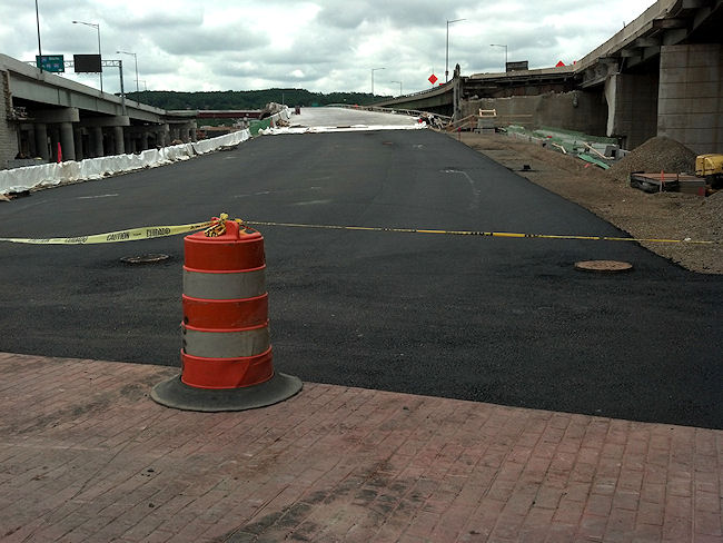 As to when/how the other new ramp that will bring traffic up to 11th Street from the Pennsylvania Avenue/Southeast Freeway connector will open, I don't know. There are a lot of traffic flow changes are coming to 11th Street between I and O over the next few months--the new ramp to the outbound freeway bridge from M just east of 11th is looking closer to completion, as is the 11th Street Local bridge. If only someone would get over there to take some photos of the progress! (Well, I did take *one.*)
 As to when/how the other new ramp that will bring traffic up to 11th Street from the Pennsylvania Avenue/Southeast Freeway connector will open, I don't know. There are a lot of traffic flow changes are coming to 11th Street between I and O over the next few months--the new ramp to the outbound freeway bridge from M just east of 11th is looking closer to completion, as is the 11th Street Local bridge. If only someone would get over there to take some photos of the progress! (Well, I did take *one.*)
One of DDOT's spiffy videos detailing all the new movements sure would be handy about now.
Comments (0)
More posts:
11th Street Bridges, Traffic Issues
Wednesday Tidbits: Osteen, Groundskeeping, and More
Apr 25, 2012 10:09 AM
After the flurry of the past few months, real news is taking a bit of a breather. In the meantime, here's some reading material I've scraped up, so that it doesn't look like I've completely quit working:
* Joel Osteen Ministries' "America's Night of Hope" is coming to Nationals Park on Saturday--here's the Washington Post's story on Osteen and the plans for the event. Doors open at 5:30 pm and the festivities start at 7 pm, if you're wanting to plan your evening around the crowds. If you're coming to the neighborhood for it, my Visiting Nats Park page can help you find your way.
* Want to know how the Nats Park field is cared for, and who takes care of it? The Post profiles head groundskeeper John Turnour and his work.
* A reader tells WashCycle about being stopped from biking on the Navy Yard portion of the Riverwalk. That promenade has always been signed as prohibiting bicycling, but with increased publicity for using the Riverwalk as a biking trail (including Tuesday's ribbon cutting of the new bridge across the CSX tracks), the issue of bicycles along the Navy Yard/Yards Park/Teague stretch is going to keep bubbling up, perhaps even moreso when the new 11th Street Local bridge opens soon with its wide pedestrian/cycling paths making the connection between both sides of the river even easier.
* Speaking of that new 11th Street Local bridge, much streetscape work has been done recently on O Street (new pavement, curbs, and brick paver crosswalks), and it looks like the concrete should be poured before too long to complete the connection from O to where the bridge begins to rise above the river. Maybe I'll actually get over there with my camera soon.
* Speaking of streetscapes, there's a new sidewalk on L Street between 1st and New Jersey, to go with the new sidewalk on Half between I and K.
* The Capitol Riverfront BID would love it if you'd fill out either their residential survey (if you live in the neighborhood) or the employee survey if you work here.
* Jonathan O'Connell at WaPo looks at how developer Opus East hit the skids, right as it was trying to finish 1015 Half Street. (Opus was also the developer behind 100 M, but it was completed before everything truly fell apart.)
* The Mayor is having a Ward 6 Fiscal Year 2013 Budget Town Hall Meeting tonight (April 25) at 6:30 pm at Eastern High School, 1700 East Capitol Street.
* The next meeting of Police Service Area 106 is on Saturday, April 28, at 10 am at the Capper Seniors building at 900 5th St., SE.
What else is going on?
UPDATE: Adding a link to Washington City Paper's profile of "The Nautical Yards", a "site-specific dance and theater piece inspired by the Washington Navy Yard" being performed at the Yards Park Thursday through Saturday (April 26-29) at 7 pm. Premium seating is $30, general admission is free.
And I should probably remind that tickets for Springsteen at Nats Park on Sept. 14 go on sale Friday (April 27) at 10 am.
Comments (15)
More posts:
1015 Half, 11th Street Bridges, Capitol Riverfront BID, Pedestrian/Cycling Issues, Events, riverwalk, Nationals Park, Stadium Events, The Yards, Yards Park
Thursday Tidbits: Roundup of Pre-Opening Day Roundups
Apr 5, 2012 11:18 AM
Before everyone disappears down the Nats Opening Day/Masters/Caps rabbit holes (myself included!), here's some links to items that might be of interest.
First, a few new entries in the What's New Around the Ballpark? lineup:
* On Tap Magazine surveys the neighborhood with "The Hidden Gem That is the Capitol Riverfront." (Another jewelry metaphor to go with the Post's "Diamond in the Rough" piece from Sunday.)
* WJLA wandered around looking at the ballpark environs.
* The Post's Going Out Gurus blog checked out the Fairgrounds' sneak peek on Tuesday. (Though what's the deal with the photos that look like they were taken through a veil? Will this Instagram obsession never ebb?)
* WTOP runs down the options for arriving at the ballpark by water taxi. (American River Taxi, by the way, says that they are almost sold out for the April 12 home opener.)
Some other items:
*