
|
| |||||||||||||||||||

|
Please note that JDLand is no longer being updated.
peek >>
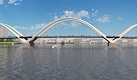
Near Southeast DC Past News Items: 11th Street Bridges

|
See JDLand's 11th Street Bridges Project Page
for Photos, History, and Details |
- Full Neighborhood Development MapThere's a lot more than just the projects listed here. See the complete map of completed, underway, and proposed projects all across the neighborhood.
- What's New This YearA quick look at what's arrived or been announced since the end of the 2018 baseball season.
- Food Options, Now and Coming SoonThere's now plenty of food options in the neighborhood. Click to see what's here, and what's coming.
![-]()
- Anacostia RiverwalkA bridge between Teague and Yards Parks is part of the planned 20-mile Anacostia Riverwalk multi-use trail along the east and west banks of the Anacostia River.
![-]()
- Virginia Ave. Tunnel ExpansionConstruction underway in 2015 to expand the 106-year-old tunnel to allow for a second track and double-height cars. Expected completion 2018.
![-]()
- Rail and Bus Times
Get real time data for the Navy Yard subway, Circulator, Bikeshare, and bus lines, plus additional transit information. - Rail and Bus Times
Get real time data for the Navy Yard subway, Circulator, Bikeshare, and bus lines, plus additional transit information. - Canal ParkThree-block park on the site of the old Washington Canal. Construction begun in spring 2011, opened Nov. 16, 2012.
![-]()
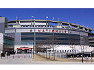
- Nationals Park21-acre site, 41,000-seat ballpark, construction begun May 2006, Opening Day March 30, 2008.
![-]()
- Washington Navy YardHeadquarters of the Naval District Washington, established in 1799.
![-]()
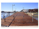
- Yards Park5.5-acre park on the banks of the Anacostia. First phase completed September 2010.
![-]()
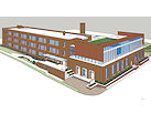
- Van Ness Elementary SchoolDC Public School, closed in 2006, but reopening in stages beginning in 2015.
![-]()
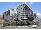
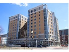
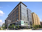
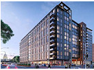
- Agora/Whole Foods336-unit apartment building at 800 New Jersey Ave., SE. Construction begun June 2014, move-ins underway early 2018. Whole Foods expected to open in late 2018.
![-]()
- New Douglass BridgeConstruction underway in early 2018 on the replacement for the current South Capitol Street Bridge. Completion expected in 2021.
![-]()
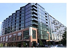
- 1221 Van290-unit residential building with 26,000 sf retail. Underway late 2015, completed early 2018.
- NAB HQ/AvidianNew headquarters for National Association of Broadcasters, along with a 163-unit condo building. Construction underway early 2017.
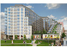
- Yards/Parcel O Residential ProjectsThe Bower, a 138-unit condo building by PN Hoffman, and The Guild, a 190-unit rental building by Forest City on the southeast corner of 4th and Tingey. Underway fall 2016, delivery 2018.
- New DC Water HQA wrap-around six-story addition to the existing O Street Pumping Station. Construction underway in 2016, with completion in 2018.
- The Harlow/Square 769N AptsMixed-income rental building with 176 units, including 36 public housing units. Underway early 2017, delivery 2019.
- West Half Residential420-unit project with 65,000 sf retail. Construction underway spring 2017.
![-]()
- Novel South Capitol/2 I St.530ish-unit apartment building in two phases, on old McDonald's site. Construction underway early 2017, completed summer 2019.
![Novel South Capitol]()
- 1250 Half/Envy310 rental units at 1250, 123 condos at Envy, 60,000 square feet of retail. Underway spring 2017.
![-]()
- Parc Riverside Phase II314ish-unit residential building at 1010 Half St., SE, by Toll Bros. Construction underway summer 2017.
![-]()
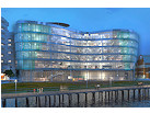
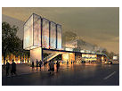
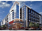
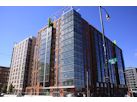
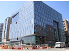
- 99 M StreetA 224,000-square-foot office building by Skanska for the corner of 1st and M. Underway fall 2015, substantially complete summer 2018. Circa and an unnamed sibling restaurant announced tenants.
![-]()
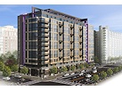
- The Garrett375-unit rental building at 2nd and I with 13,000 sq ft retail. Construction underway late fall 2017.
![-]()
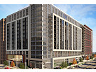
- Yards/The Estate Apts. and Thompson Hotel270-unit rental building and 227-room Thompson Hotel, with 20,000 sq ft retail total. Construction underway fall 2017.
![-]()
- Meridian on First275-unit residential building, by Paradigm. Construction underway early 2018.
![-]()
- The Maren/71 Potomac264-unit residential building with 12,500 sq ft retail, underway spring 2018. Phase 2 of RiverFront on the Anacostia development.
![-]()
- DC Crossing/Square 696Block bought in 2016 by Tishman Speyer, with plans for 800 apartment units and 44,000 square feet of retail in two phases. Digging underway April 2018.
![DC Crossing]()
- One Hill South Phase 2300ish-unit unnamed sibling building at South Capitol and I. Work underway summer 2018.
![One Hill South Phase 2]()
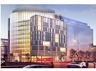
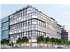
- New DDOT HQ/250 MNew headquarters for the District Department of Transportation. Underway early 2019.
![New DDOT HQ]()
- 37 L Street Condos11-story, 74-unit condo building west of Half St. Underway early 2019.
![37 L Condos]()
- CSX East Residential/Hotel225ish-unit AC Marriott and two residential buildings planned. Digging underway late summer 2019.
![CSX East Residential/Hotel]()
- 1000 South Capitol Residential224-unit apartment building by Lerner. Underway fall 2019.
![1000 South Capitol Residential]()
- Capper Seniors 2.0Reconstruction of the 160-unit building for low-income seniors that was destroyed by fire in 2018.
![1000 South Capitol Residential]()
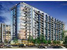
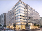
- Chemonics HQNew 285,000-sq-ft office building with 14,000 sq ft of retail. Expected delivery 2021.
![1000 South Capitol Residential]()


159 Blog Posts Since 2003
Go to Page: 1 | ... 11 | 12 | 13 | 14 | 15 | 16
Search JDLand Blog Posts by Date or Category
Go to Page: 1 | ... 11 | 12 | 13 | 14 | 15 | 16
Search JDLand Blog Posts by Date or Category
On Monday (May 7), DDOT is having a media briefing to announce that construction has begun on the Anacostia Riverwalk Trail. This is the first phase, and so doesn't actually include the planned portion of the trail through Near Southeast (from the 11th Street Bridges to the Frederick Douglass Bridge)--according to the AWC page and a meeting AWC held a few weeks back, I believe what's now being constructed is Phase I, the trail on the west side of the Anacostia from the Navy Yard to the National Arboretum. Phase 2 will be on the east side of the river, from Poplar Point to Pennsylvania Avenue, and Phase 3 (the Near Southeast portion) is probably looking at a 2010 date (when the Waterfront Park at the Yards is completed, and they can build the pedestrian bridge to link that park to Diamond Teague Park and Florida Rock.
UPDATE, May 7: A post-briefing press release says that the section of the Riverwalk now under construction is a two-mile stretch that will run from the Navy Yard east to Benning Road. There's also a link to a fact sheet on the trail (albeit from June 2006) that has a map of the planned trail and other information. And here's a WTOP piece on the new section.
|
More posts:
11th Street Bridges, Anacostia Waterfront Corp., Pedestrian/Cycling Issues, East of 11th Street, Florida Rock, Navy Yard, riverwalk, Teague Park, The Yards
|
You would think that a new Environmental Impact Statement of the 14th Street Bridge Corridor would be outside of my Near Southeast scope, but they managed to sneak the boundary area just past South Capitol Street. So, it becomes another study I will grudgingly pay attention to, along with the South Capitol Street EIS and the 11th Street Bridges EIS (both of which have gone reeeeeal quiet lately, with the 11th Street Bridges EIS having missed its release deadline of Fall 2006). See this flyer for information on the 14th Street Bridge Corridor public workshops, on Feb. 27 at Amidon Elementary in Southwest and Feb. 28 in Arlington.
And speaking of Boundary Creep, the Washington Business Journal reported last week that the Office of Planning has "has initiated a major effort to expand the boundaries of the traditional office and entertainment areas, creating a planning zone called Center City. The initiative more than doubles the area traditionally considered downtown by adding the North of Massachusetts Avenue area (NoMa) as well as the Southeast and Southwest waterfronts. Another objective is to provide better links to tie the traditional downtown zone with emerging business and entertainment districts, the waterfront and the National Mall. Center City will be promoted as a waterfront city with nearly half of its boundary defined by the Potomac and Anacostia rivers." You can see the OP's Center City page for more details about this project, which I am admittedly giving short shrift here (I figure there will be plenty more items to come). Who'd a thunk it--it turns out Near Southeast is DOWNTOWN, baby!
|
More posts:
11th Street Bridges, South Capitol St.
|
Monday's DC Examiner reports: "The Transportation Planning Board added more than $1 billion in projects for the District to the region's long-range transportation plan, according to officials. The stratagem, called the Constrained Long Range Plan, estimates about $4.5 billion will be available each year for the next 24 years to complete projects in Maryland, Virginia and the District. Projects can only be added to the board's long range plan if there is a solid funding mechanism in place. " Three of the DC projects will impact Near Southeast: the rehabilitation of South Capitol Street including transformation of the street into an at-grade boulvard from I Street to N Street and the construction of a new Frederick Douglass Bridge (costing $625 million and completed in 2015); the reconfiguration and reconstruction of the 11th Street Bridges (costing $377 million and completed in 2011); and $3 million for the Anacostia Streetcar Study, which would run light rail across the 11th Street Bridges from Anacostia down M Street SE to South Capitol Street. (The first phase of actual construction of the Streetcar Project has been added to the CLRP as well.) Here's an explanation of the CLRP as well as the Transportation Improvement Plan, which describes the schedule for federal funds obligated to state and local projects.
|
|
Public comment has now closed on the 11th Street Bridges Draft Environmental Impact Statement; the Sierra Club has posted it's comments submitted to DDOT about the project (hat tip to Richard Layman). And the September Hill Rag has an article about the Anacostia Community Boathouse Association's attempt to save the boathouse buildings nestled between the two bridge spans. (See also my August 10 entry on this issue.)
|
More posts:
11th Street Bridges, Boathouse Row
|
The hot-off-the-presses Aug. 10 Voice of the Hill (PDF) has a front-page report about the efforts to save the 106-year-old Anacostia Community Boathouse, under threat because of the pending changes to the 11th Street Bridges. The boathouse is one of the two red-brick buildings that are on the Anacostia River shore, right in between the two bridge spans (the second building, which is not in danger of being demolished, was recently the recipient of a $300,000 grant from DDOT to help its renovation). The 11th Street Bridges Environmental Impact Study, currently underway, has ID'ed four different build options for the bridges (to better link them to the Anacostia Freeway), and three of those options impact the boathouse. Public comment on the EIS is being accepted until Aug. 28. UPDATE: Oops, should have included this link to the Anacostia Community Boathouse Association "Save the Boathouse" page.
|
More posts:
11th Street Bridges, Boathouse Row
|
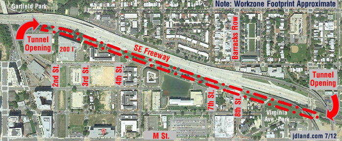
Don't forget, the two public hearings on the 11th Street Bridges Draft Environmental Impact Statement are Wednesday and Thursday night--Wednesday's is at 1105 New Jersey Ave., SE (St. Matthew's Baptist Church), and Thursday's is at 2041 Martin Luther King Jr. Ave. (Anacostia Professional Building). Both are from 6:30 to 8:30 pm. UPDATE: Here are the meeting packet, opening presentation, and display posters for the two meetings. And the entire Draft EIS is available, too. UPDATE II: Having just now really been able to take a look at these materials, I highly suggest taking a few minutes to look at the display posters. They do a great job of showing the four different build alternatives currently under consideration for the bridges, how they would impact both sides of the river, and more. Whichever one they choose, being able to have access to northbound I-295 from the SE Freeway (and vice versa), without having to go across Pennsylvania Avenue and make that left turn, has to be considered a vast improvement.
|
More posts:
11th Street Bridges
|
Voice of the Hill reports that ANC 6B "voted unanimously July 11 to support preliminary plans for a project that would connect the Southeast Freeway with the Anacostia Freeway." This is the 11th Street Bridges project, which "would allow southbound motorists on the Anacostia Freeway to access the 11th Street Bridges and motorists on the bridges to go north on the freeway, thereby creating a link between the Anacostia and Southeast freeways." There are public hearings on July 26 and 27 on the project's draft environmental impact statement, and public comment is being accepted until August 28.
|
More posts:
11th Street Bridges, ANC News, Traffic Issues
|
The 11th Street Bridges Draft Environmental Impact Statement (EIS) has been released. Two public meetings have been scheduled, on July 26 and 27; the comment period extends until August 28, 2006.
|
More posts:
11th Street Bridges
|
It hasn't been posted on their web site yet, but the agenda for Tuesday's ANC 6D meeting has a couple Near Southeast-related items: recommendations by Development Committee on Closing Of Public Alleys In Square 743N, a presentation by the DC Preservation League on a possible Historic Designation of Navy Yard Car Barn, i.e., the "Blue Castle" (the case is coming before the DC Historic Preservation Review Board on March 23); and a presentation of the 11th Street Bridges study. It's at 7 pm Tuesday, at 65 I Street SW. UPDATE: I've been told that additional items have been added, both of which are Near Southeast-related: a request for support by the Van Ness Elementary principal to keep the school open (I've heard in the past that it would be closing, but that it would be temporary, maybe things have changed?), and an update from the DC Sports and Entertainment Commission about the new baseball stadium. Also, here are the minutes from the February meeting.
|
|
The South Capitol Street Environmental Impact Statement project has posted its Winter 2006 newsletter with the latest updates on the study. Two build alternatives have been identified and are briefly described--the less costly one would keep the South Capitol and M intersection in two levels, and would create a "traditional" intersection at Potomac Avenue. The second and more wide-ranging alternative would reconstruct South Capitol and M to be "at-grade", and would create a traffic circle interchange at Potomac Avenue (there are differences in the two plans for east side of the bridge as well). The various plans (the two build alternatives, plus a "Transportation System Management" alternative and a No-Build alternative) will be presented at public meetings later this winter, then there will be ANC meetings, environmental analyses, and finally the preparation of the draft EIS. In the meantime, DDOT will be discussing this project as part of its Feb. 25 Open House. Also, both the South Capitol Street EIS and the 11th Street Bridges EIS teams will present their pedestrian and bicycle concepts to a meeting of the Bicycle Advisory Council on March 8. See my South Capitol Street and South Capitol Street Bridge pages for more details, photos, links, etc.
|
|
159 Posts:
Go to Page: 1 | ... 11 | 12 | 13 | 14 | 15 | 16
Search JDLand Blog Posts by Date or Category
Go to Page: 1 | ... 11 | 12 | 13 | 14 | 15 | 16
Search JDLand Blog Posts by Date or Category